Hello everyone!
We have quite a few tropical systems to watch today as we continue moving through the peak of hurricane season. This post will discuss a disturbance emerging in the general vicinity of the Bahamas and what implications it might have for the US East Coast. I have also posted updates on Nicholas in the Gulf of Mexico and a tropical wave about to emerge off Africa.
This disturbance’s forecast starts with an upper-level low spinning north of the Dominican Republic seen on satellite imagery below.
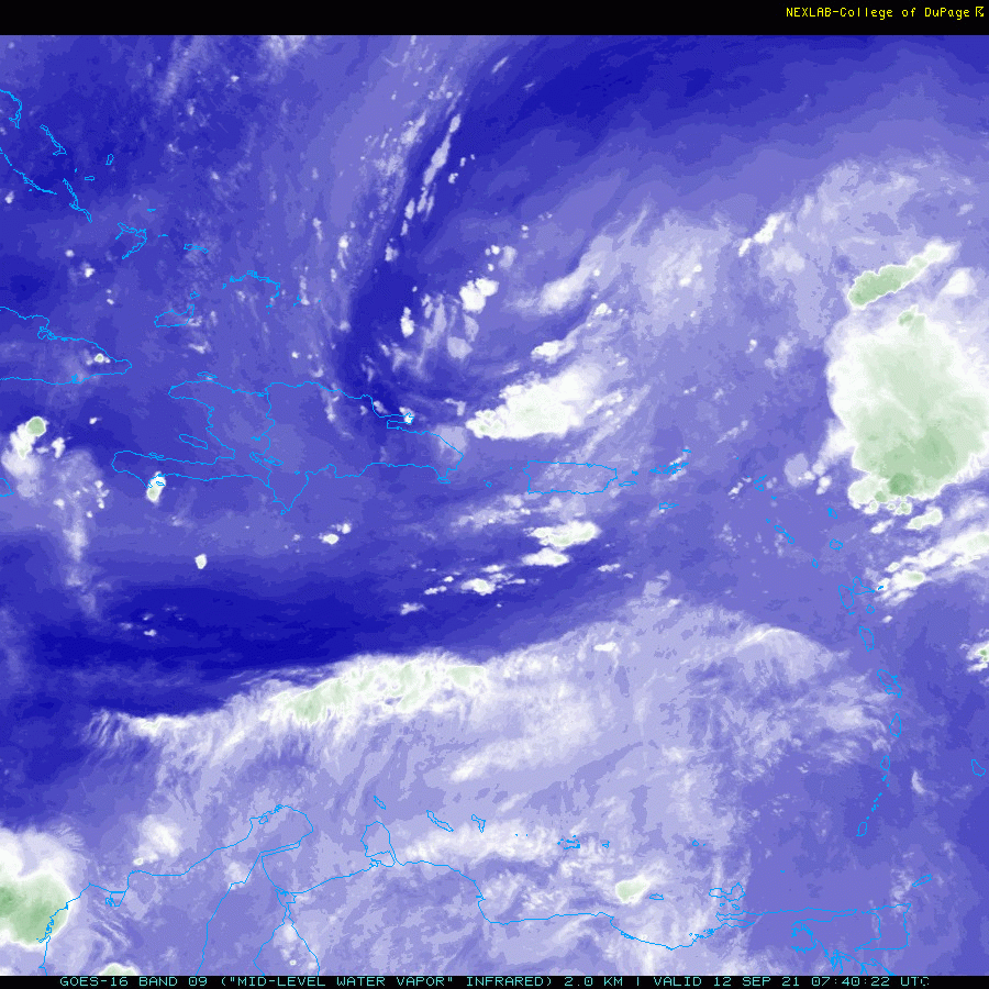
Note that the cirrus (clouds streaming off the green thunderstorms) are spinning counter-clockwise around this system, indicating cyclonic flow aloft. This is a signal that the system is non-tropical in origin, having a pocket of cold air at its center rather than the pocket of warm air characteristic of tropical cyclones. That said, you’ll also notice plenty of thunderstorm activity under and especially east of the swirl’s center. Thunderstorms release heat into the atmosphere by converting water vapor into droplets and ice, so if thunderstorm activity persists for long enough, the cold pocket will get eroded and replaced by a warm pocket.
That’s exactly what’s expected to happen over the next couple days as the system drifts NW.

An animation of surface pressure/winds and simulated reflectivity shows how the system should gradually acquire some spin at the surface (right now, the spin is all above the surface). At the moment, it seems likely that the system will miss the Bahamas to the northeast, though some gusty showers are possible as it moves past.
Because the system will have to reverse the flow of the winds in the upper-levels and not just create its own pocket of warm air, but completely reverse a pre-existing cold pocket, development should be on the slower side.
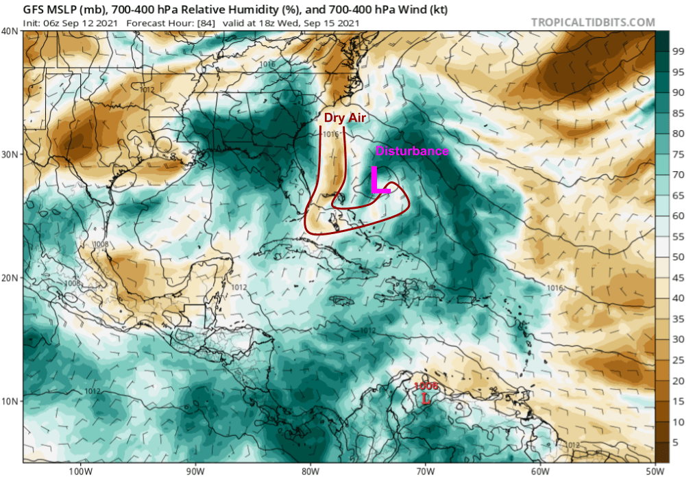
Due partly to its non-tropical origins, this system will also have to deal with a bit of dry air on its western/southwestern side. I don’t think this will preclude development, but it’s one reason I’m not super worried about this rapidly intensifying.

There’s a fair bit of spread in where the system actually emerges and tracks over the next 5 days or so. GEFS ensemble members are in pretty solid agreement that a TD/TS will gradually form out of this system as it moves NW over the Gulf Stream. But there are questions about where exactly within the current swirl a surface system can spin up, and questions about the forces that will dictate its path. That said, it looks like the system’s center probably stays out over water and likely ends up somewhere east or south of the Outer Banks by Thursday evening.
Whatever happens to the storm’s center, the bigger and more important story will be its associated plume of tropical moisture.
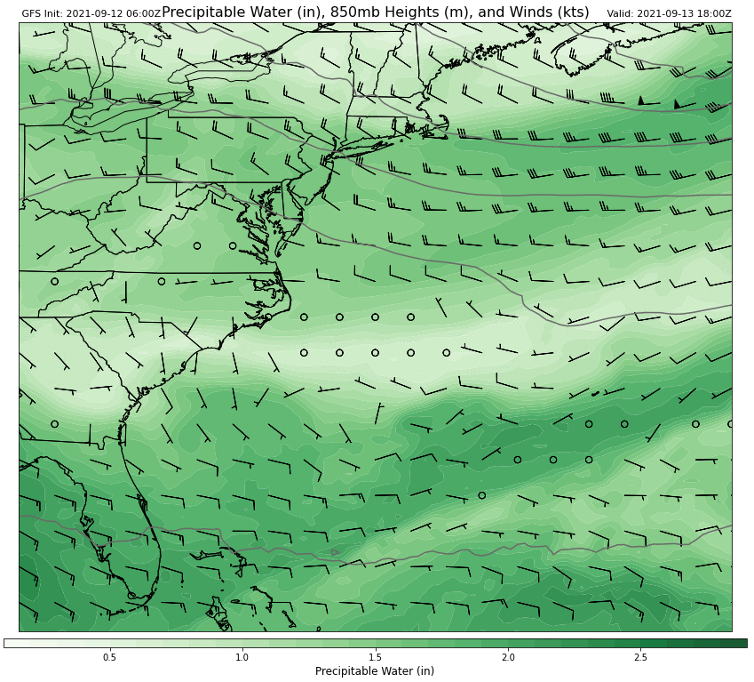
This animation shows the system’s moisture plume advancing northwest over the next 5 days as southerly flow develops on the eastern side of the system and west of the Bermuda high.
What happens late next week then becomes crucial to determining what impact the system might have in the US.

Ensemble guidance gives us a good luck at the general pattern, which will be a classic autumnal clash of airmasses. To the north, we have Canadian high pressure providing cool and dry air. This airmass will try to play defense as moisture associated with this tropical disturbance surges north.
It’s not yet clear how this battle will play out, but the stakes are rather high since it won’t take much moisture to produce heavy rain and it won’t take much heavy rain to cause problems over waterlogged NY/NJ. To be quite clear there is nothing about this setup that evokes Ida’s dynamics, and similarly catastrophic impacts are not expected at this time. That said, we’ll be watching closely to see what happens with this system as any shifts in track to the west may result in a substantial heavy rain/flash flooding threat for parts of the Mid Atlantic/Northeast.
-Jack
