Hello everyone!
through the peak of hurricane season. This post will focus on a tropical wave just emerging from Africa that may be one to watch for potential impacts to land in the longer range. I have also posted updates on Tropical Storm Nicholas in the Gulf of Mexico and a system developing near the Bahamas.

Satellite imagery shows two tropical disturbances of note over Africa and the far eastern Atlantic. The western disturbance is located just north of the Cabo Verde islands. Its thunderstorms are gradually fizzling thanks to the cooler waters below and drier air above. It seems unlikely at this point that the system would become a tropical cyclone, but even if it does, it will be brief and uneventful.
The more interesting feature is that big blob of red moving over southern Mali. This is a stronger wave that will emerge at a lower latitude than the first, meaning it has a better shot at developing and a better shot of making it far enough west to cause problems for land in the form of a tropical cyclone (obviously the wave in its current form is impactful to western Africa even though it’s not a tropical cyclone).
More likely than not, this wave will become a TD/TS shortly after moving over water tomorrow. It will then have a fairly favorable environment to intensify as it heads west over the open ocean. By this time next weekend, it has a pretty good shot at being a hurricane east of the Lesser Antilles.
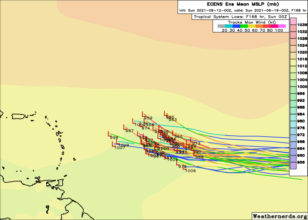
ECMWF ensembles are nearly unanimous in showing development of this system into a tropical cyclone, with about half of members showing a low strong enough to be a hurricane.
What happens after this is obviously the big question.
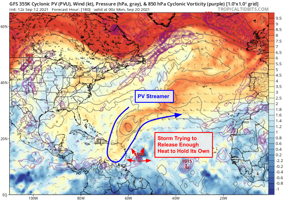
Some model guidance suggests there will be a “PV streamer” or pocket of cold air aloft northeast of Puerto Rico as this system approaches the Lesser Antilles. This is a useful place for a feature like this if you’re in the Caribbean because if the storm is on the weaker side (TS/Cat 1), it will probably get ripped apart by the PV streamer’s shear. If the storm is stronger, it might be able to bully the PV streamer with its outflow, but it is also more likely to get steered more north by the PV streamer’s southwesterly flow aloft.

However, before we get too excited about the PVS, a lot has to happen for it to end up in exactly the right time and place to either slice the head off a weaker storm or guide a stronger one away from land. Note that the high-PV air (red shadings) that becomes this PVS originates over the northwest Atlantic early in the forecast period. This is dislodged in part by the outflow generated by the storm developing near the Bahamas which has its own PVS to contend with (the one from which it is being born). So a weaker system over there could lead to a weaker PVS or one that doesn’t slide as far southeast.
Similarly, there’s some uncertainty regarding the track of the potential hurricane. If the storm tracks a little farther north and can slip northeast of the PVS, it could actually benefit from the interaction through enhanced ventilation.
So while there is reason to be cautiously optimistic about what might await this potential storm as it approaches the Lesser Antilles, the forecast is far from a slam-dunk this far out. We’ll just need to wait a few days to see how both the disturbance itself develops and how the system up in the Bahamas shapes up.
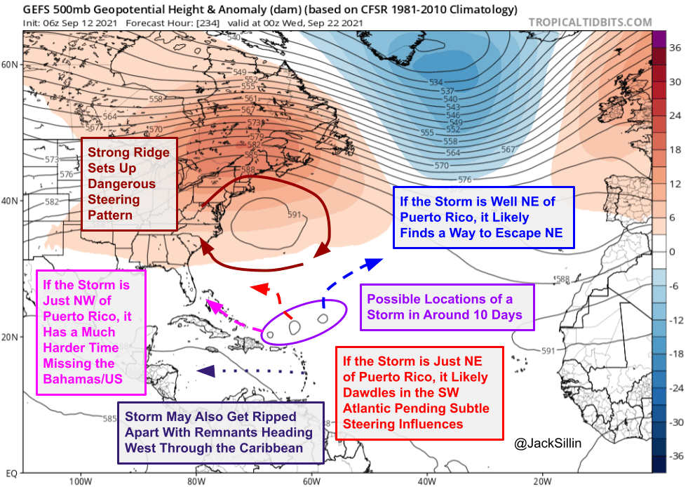
What happens after that is more or less anyone’s guess. That said, there is some reason to watch this storm extra carefully. A long train of events starting with Typhoon Chantu currently east of Taiwan will likely place a strong ridge of high pressure between Bermuda and the US East Coast. This would block the exits for a storm in the SW Atlantic, depending on where exactly it ends up.
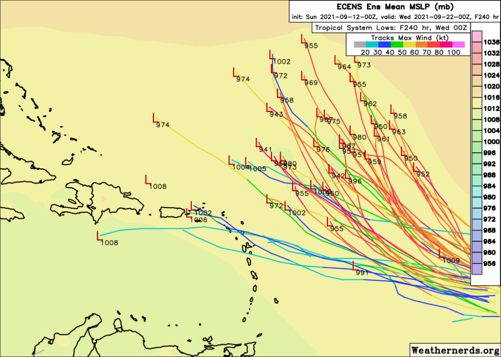
Ensemble forecasts currently suggest the most likely position for the storm around 10 days from now is somewhere north or northeast of Puerto Rico. If that ends up being the case, we’d have to watch very carefully for more subtle steering influences that could either let it dawdle over the open ocean south of Bermuda or potentially head west. However, a storm that’s a bit faster and ends up north or northwest of Puerto Rico could end up being a significant concern for the Bahamas and the US East Coast.
There’s still a lot of time to watch this system, but it’s one worth checking in on every couple days given the pattern it’s likely to find over the western Atlantic.
-Jack
