Hello everyone!
We have quite a few tropical systems to watch today as we continue moving through the peak of hurricane season. This post will focus on the system we’ve been watching in the Gulf of Mexico which has now become sufficiently organized to have earned the title of Tropical Storm Nicholas. I have also posted updates on a system developing near the Bahamas and one about to emerge off Africa.
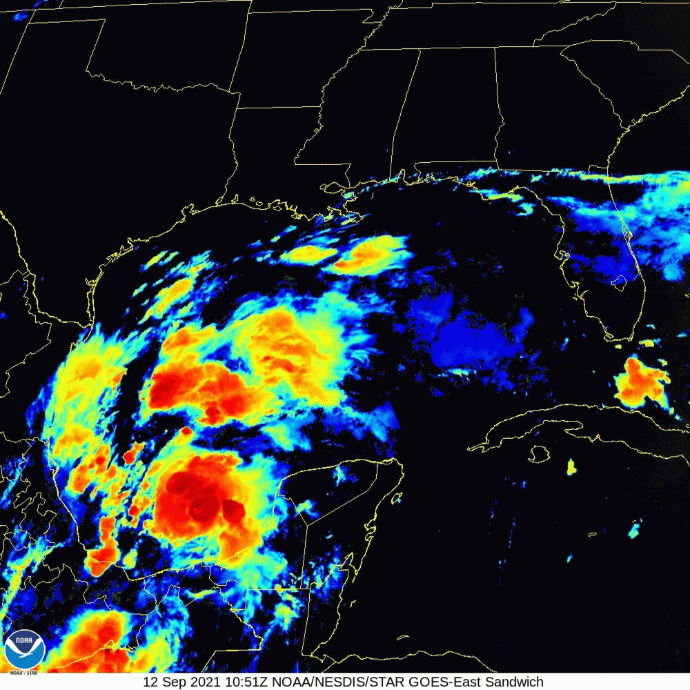
Satellite imagery shows plenty of convection associated with the system as well as an expanding plume of cirrus racing off to the north/northeast. This is a general hint that the upper-level environment is becoming more favorable for the system’s development. That said, the storm’s thunderstorm activity still has some organizing to do. It’s not yet totally obvious which convective cluster will become dominant, though I have my money on the one due west of the northwestern tip of the Yucatan.
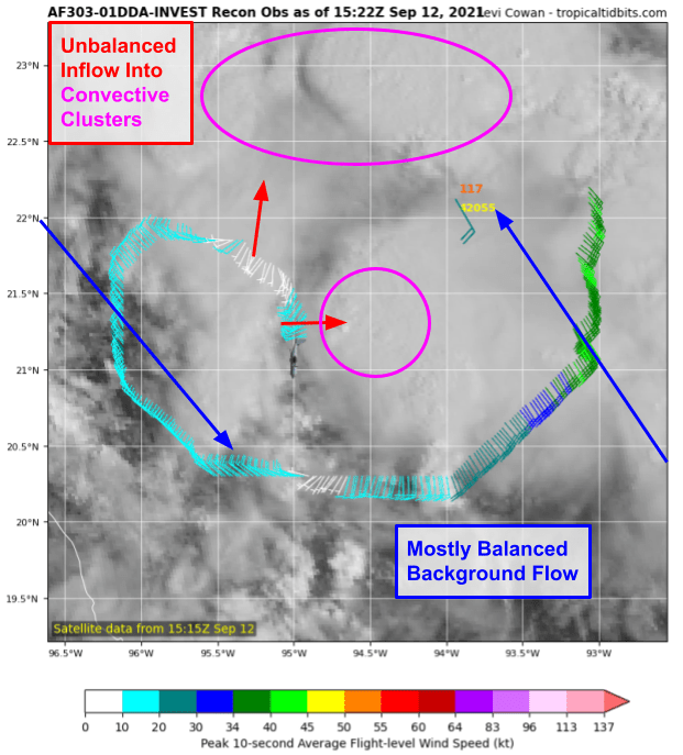
Hurricane Hunters have been investigating the storm this morning, and are reporting data that’s rather interesting for us weather nerds. We’re seeing a step in the tropical cyclone formation process that usually happens either too fast or too far out to sea for us to measure. After thunderstorms form and release latent heat, lowering the pressure near the storm’s center, air from farther out in the system starts to rush towards the thunderstorms to fill the “gap” that is the low pressure area. This “rush” of air actually starts out in a straight line without spin! It isn’t until the air is already in motion that Coriolis kicks in and deflects the movement of the air to the right, giving a storm its spin.
I suspect this is what we’re seeing in the recon data showing straight-line inflow towards convective clusters rather than the smoothly curved wind field we’d expect from a tropical cyclone. That will come later, we just need to let the storms and Coriolis do their things.
Nicholas will move northwest today and tomorrow through an environment that looks relatively favorable for tropical cyclone development. There’s good anticyclonic flow in the upper levels of the atmosphere which will help keep shear low and ventilation high. For now, there isn’t too much dry air near the system though that will change starting tomorrow afternoon/evening. Over the Gulf of Mexico this time of year, you never need to worry about ocean temperatures being too cold to support a tropical cyclone.
With that in mind, intensification should be steady and possibly bordering on rapid for the next 24-36 hours or so as Nicholas approaches Texas. The most likely outcome right now is for landfall to occur on Tuesday as a strong tropical storm, but I could see anything from a mid-grade TS to a Category One hurricane.
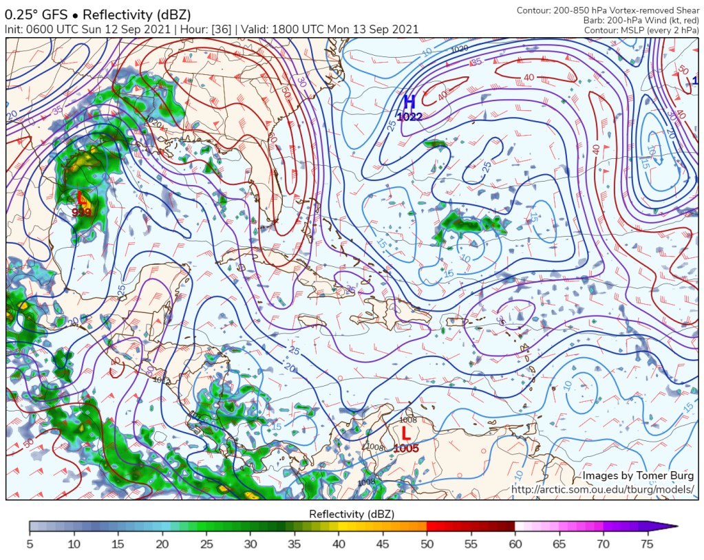
Will Nicholas rapidly intensify into a major hurricane? It’s a question I’ve gotten a few times, for reasons I totally understand. We just saw Ida rapidly intensify over the Gulf a couple weeks ago and Harvey underwent a burst of RI in this part of the Gulf just a couple years ago. Thankfully, I don’t think we’ll see something as crazy as either of those systems for reasons outlined in the graph below.

This plot shows average atmospheric conditions over and around Nicholas as it moves along the Texas coast Monday night. The first thing to note is how the green line veers left of the red line between 200 and 500mb. This indicates a dew point lower than the temperature or, in more useful terms, dry air. There will be dry air moving off the Mexican highlands towards Nicholas as it tracks along the Texas coast, likely leading to disruption of the storm’s core. This disruption will be assisted by 25-30kt westerly winds in that layer providing shear and extra momentum for the dry air to punch into the core. Of course there’s also the possibility that the storm wanders even a few miles west and moves inland, away from its supply of fuel.
So we’ll keep a very close eye on things as we would for any system over the Gulf in a quasi-favorable environment especially tonight/tomorrow, but there are really solid reasons to bet against rapid intensification into a major hurricane (Cat 3+) right near landfall.
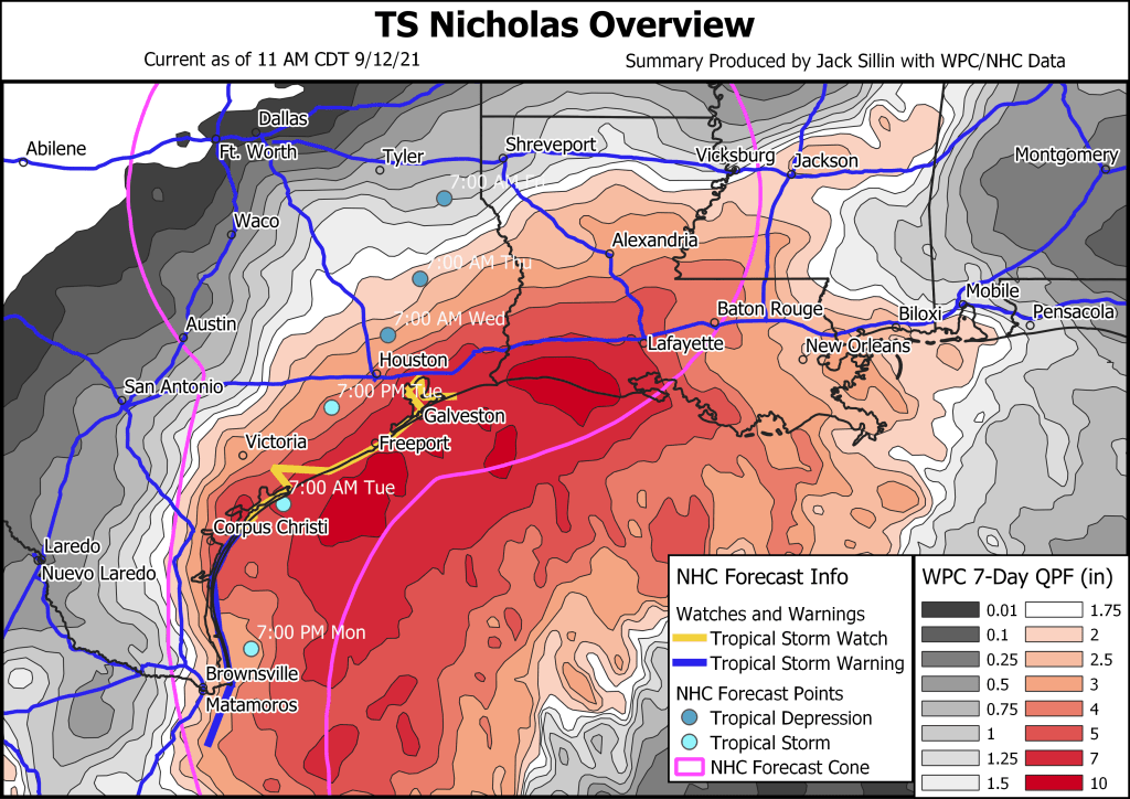
Here’s a quick overview of the NHC/WPC forecasts for the system’s track/intensity and its rainfall. The NHC track/intensity forecast calls for the center to scrape along the Texas coast from Brownsville up towards Corpus Christi as a strong TS before moving inland towards Houston. Note that if the system wobbles to the western edge of the track, it would make this journey entirely inland, weakening/dissipating as it went. On the other hand, a wobble towards the eastern edge of the cone would put the storm over the Gulf for much longer, potentially leading to more significant intensification (though remember the dry air/shear should hold that in check).
Of more pressing concern is the rainfall forecast which shows 5-10″+ of rain falling from Corpus Christi all the way east to Lafayette Louisiana as a trough of low pressure extending north-northeast from Nicholas helps wring out tropical moisture hundreds of miles from its center.
Nicholas’ intensity will also have an impact on who gets the most rain and how much ends up falling in total.
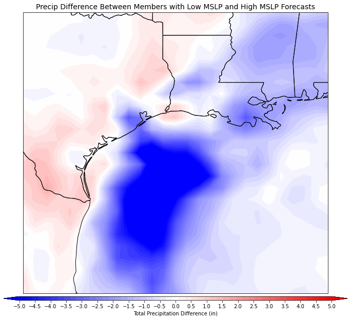
This plot shows the rainfall difference between 5 iterations of the GFS (part of the GEFS) showing a weaker system (higher MSLP in the western Gulf) and 5 iterations showing a stronger system (lower MSLP). Negative numbers (blue shadings) mean that members showing a stronger system have more rain, while red shadings indicate who would see more rain from a weaker system.
It’s clear that a stronger system would drop more rain over the Gulf (that’s good!) as it would also track a bit farther east. But it would also likely be able to drop more rain over Houston and especially Louisiana thanks in part to the track farther east as well as more robust northeastward moisture transport. On the other hand, a stronger system would also draw more dry air in from Mexico leading to significantly less rain over Brownsville, Corpus Christi, and points west.

Here’s a look at how the GFS expects Nicholas to develop, move north, and eventually fade in the face of dry air and shear. Obviously it’s just one model so it’s depiction isn’t written in stone, but I think it does a good job highlighting the general progression of the storm. Rain from the trough north of the system will arrive in coastal Texas tonight before the center approaches Tuesday. The system will then turn northeast before dissipating somewhere over eastern TX or LA, though heavy rain may continue to move east into MS/AL/FL.
-Jack
