Hello everyone!
Tropical Storm Ida continues to move through the northwestern Caribbean this morning, intensifying as it does so.

The storm looks much healthier on satellite imagery this morning than it did last night. Persistent and intense thunderstorm activity is parked over the storm’s center, allowing for the vortex to align and intensification to commence. Cirrus continues to fan out away from the system in all directions, indicating a good upper-level environment to support robust outflow.

Hurricane Hunters have been flying through Ida this morning and found some hurricane-force winds up at flight level just northeast of the center. These winds may not have mixed down to the surface yet, so it’s probably not quite a hurricane officially. That said, the trend is clear. The storm’s low-level center is now tucked under its mid-level center and surrounded by intense thunderstorm activity. It is rapidly intensifying and should continue to do so today.

This map shows Ida’s forecast environment this afternoon as it nears the far western tip of Cuba. Ocean temperatures will be roughly 29C, more than supportive of a major hurricane. Wind shear will be similarly friendly to the storm, decreasing to around 10kts. A powerful upper-level anticyclone will help ventilate the system and dry air currently holding back its southwestern flank is expected to retreat farther south out of the storm’s path. There’s nothing to stop continued rapid intensification into a hurricane later this afternoon before landfall in Cuba.

Western Cuba is much flatter and friendlier to tropical cyclones than the southeastern tip of the island we so often talk about when watching storms interact with the island. The island is very narrow where Ida will cross, with just a few hills sticking more than 1000 feet above the ocean. Ida won’t be able to continue strengthening for the couple hours it’s over Cuba, and if it has an exceptionally tiny/fragile core we may see some disruption, but the storm is very unlikely to be disrupted significantly by Cuba.
It will be back over water tonight in the southern Gulf of Mexico where it will be full steam ahead in an environment that is as favorable as it gets.
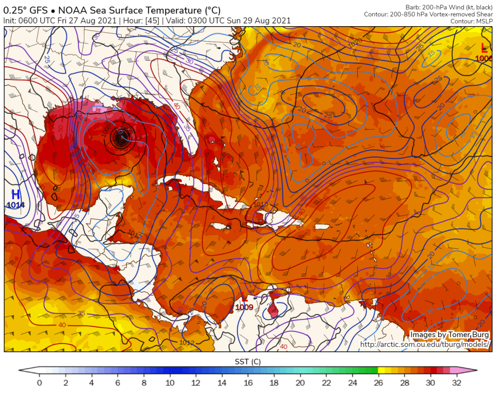
If I were charged with writing a textbook on perfect conditions for tropical cyclone intensification, the Gulf of Mexico tomorrow evening could provide much of my material. The water is extremely warm (30-32C!), that warmth is deep meaning that it will be nearly impossible to stir up colder water from the subsurface ocean, wind shear is almost nonexistent (<10kts), and there is no dry air in sight.
The official NHC forecast calls for a maximum intensity of about 120mph just before landfall in Louisiana, which would make Ida a Category Three. I’ll take the over.
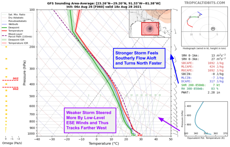
As we discussed yesterday, the stronger Ida gets, the farther east it’s likely to track due to how the winds shift a bit with height. Given Ida’s intensity trends today (strengthening faster than anticipated) and a bit of a wobble in its track (northeast towards the deeper convection), I think it’s reasonable to assume we’ll see a slight nudge east in the storm’s forecast track over the Gulf.
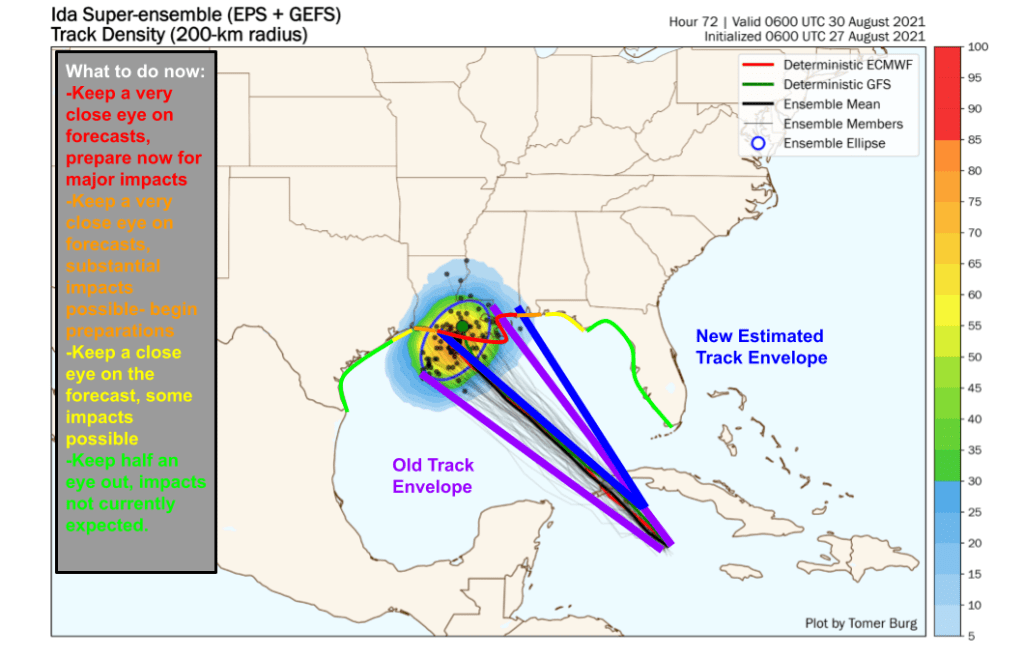
Here’s what I expect that to look like in the context of current ensemble guidance. At this point, I feel pretty comfortable writing off Texas for direct impacts from Ida’s core, though rain bands and gusty winds will extend very far from the center. A westerly wobble would now mean Lake Charles rather than Houston. The center is most likely to pass near or a bit west of New Orleans, placing the city in the most ferocious “right-front” quadrant where the storm’s forward motion augments the circulation to boost wind speeds.
The right-front quadrant is also where Ida’s worst surge will be found. You don’t need me to tell you New Orleans and storm surge haven’t always gotten along. Thankfully, in the wake of Katrina, the city and the Army Corps of Engineers invested in a flood protection system designed to hold back a surge event that occurs on average once every 100 years (in other words, it has a 1% chance of happening in any given year). Maps produced by the City of New Orleans show the magnitude of a theoretical storm like this.
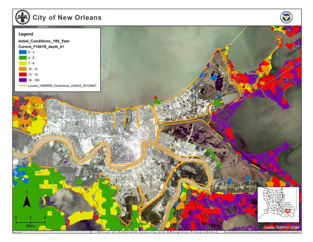
The levee system thus should be good to hold back 12-16+ feet of surge.

The latest NHC forecast shows about 7-11′ of surge in New Orleans. So the levees should be good, but a massive threat to life and property exists outside the flood protection system. We’re knocking on the door of “unsurviveable” surge capable of inundating the second story of well-constructed buildings. If Ida intensifies further, we may well see such language introduced by the NHC. Either way, please heed evacuation notices if you’re in the storm’s path.
I’ll have another update this evening as the storm emerges into the Gulf. You can also follow me on twitter for more frequent musings @JackSillin.
-Jack
