Hello everyone!
A disturbance in the Caribbean near Jamaica continues to slowly organize this morning. The system was tagged as Invest 99L by the NHC yesterday, so we now have a few more tools to keep an eye on it. 10:15 AM Update: 99L is now TD9 after satellite imagery provided convincing evidence of a low-level circulation.
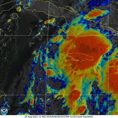
Satellite imagery this morning is actually a bit underwhelming. The strongest thunderstorm activity is northeast of Jamaica while the center is southwest of the island. We’ll need to see more concentrated thunderstorm activity near the developing center before the storm gets a name and begins really intensifying.

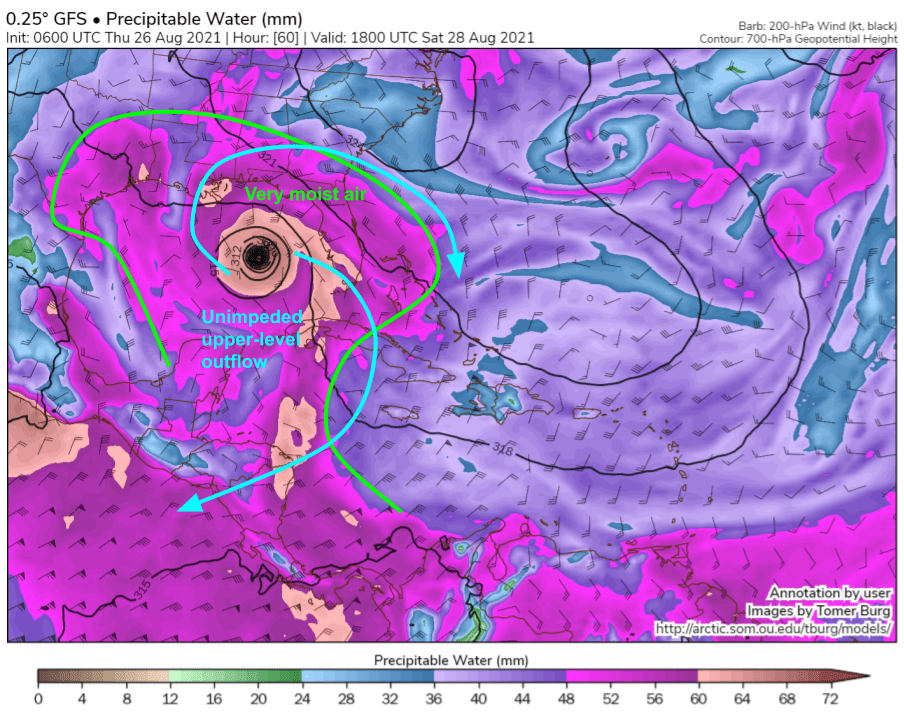
The reason for 99L’s lackluster southwestern flank today is evident in the model forecast map shown above which depicts moisture, mid/upper-level winds, and mid-level geopotential heights (analogous to barometric pressure but for levels higher in the atmosphere). Note the pocket of drier air lurking southwest of the system, and the west-southwesterly winds pushing that dry air towards 99L. This is likely to limit 99L somewhat in the short term, though some guidance including the GFS shown above, indicates that a small core might be able to emerge and wall off the dry air tonight. Whether or not this happens is largely a matter of small-scale thunderstorm interactions that are very difficult to anticipate ahead of time.
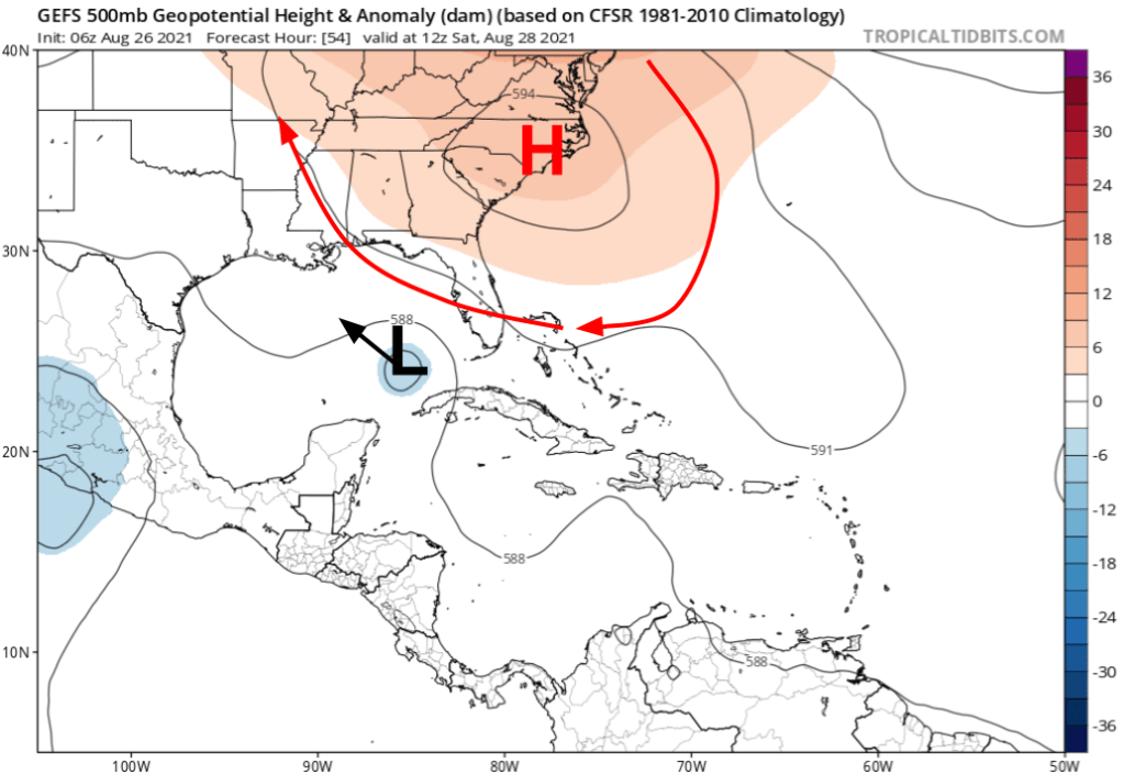
On Saturday, 99L will almost certainly be TS Ida in the far southeastern Gulf of Mexico. During this time, a ridge of high pressure will build over North Carolina. This feature will shove the storm left a bit. How far left? That depends on the strength of the ridge (pretty intuitive) as well as the strength of the storm (perhaps less intuitive).
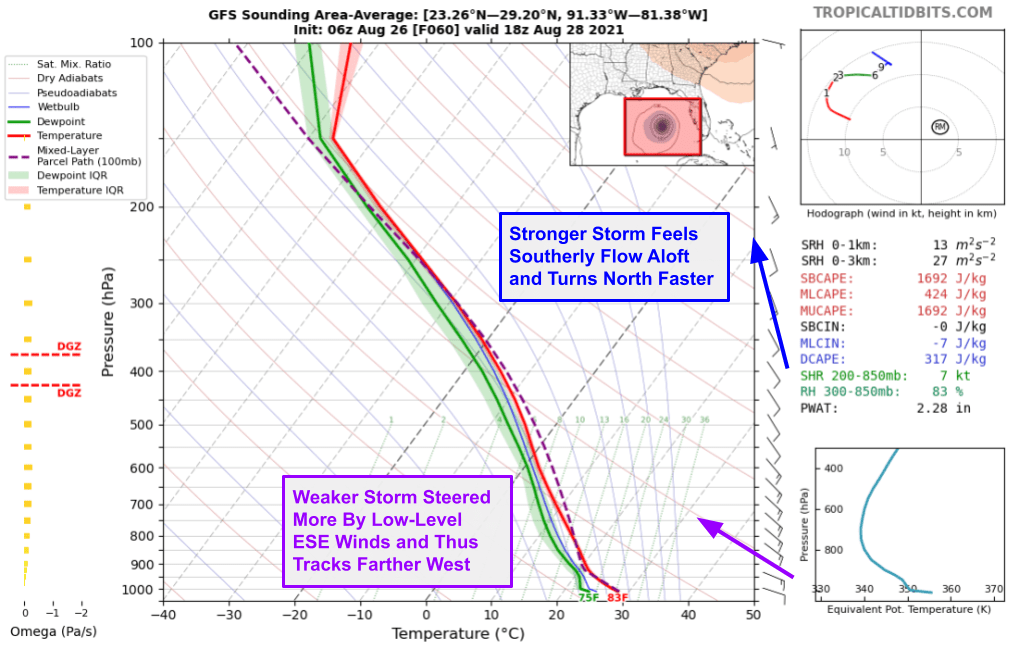
This chart depicts average conditions around 99L in the Gulf of Mexico on Saturday. Because the average is taken across the whole storm, the vortex is removed (the northerlies on the west side cancel out the southerlies on the east side and so on) and we just get the background steering wind flow. Note that the winds closer to the ground have more of an easterly component while winds farther up have more of a southerly component. A tropical cyclone is steered by winds in a layer of the atmosphere beginning near the surface and extending up some distance depending on the storm’s strength. The stronger the storm, the deeper the relevant steering layer, and the more of those southerly winds 99L will “feel”.
So here’s what this all means from a forecast perspective.
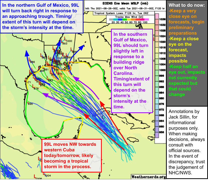
TD9 will move northwest today and tomorrow, potentially landfalling in western Cuba. It will then wobble west on Saturday, maybe a little (if it’s strong and/or the ridge is weak) or maybe quite a bit (if it’s weaker and/or the ridge is stronger). An approaching trough will then turn the system back towards the north and eventually northeast with landfall expected somewhere along the Gulf Coast. Right now, Louisiana is the most likely place for landfall but I wouldn’t be surprised to see that wobble a bit towards MS and I still can’t totally rule out impacts over in TX.
The environment in the Gulf looks extraordinarily favorable for intensification which will likely be rapid.
By Saturday, there will be very little dry air in the vicinity of the system, upper-level outflow should be nearly perfect with just a bit of constriction to the southwest. Ocean temperatures are up above 30C (you need about 26-27C to support a tropical cyclone) which will provide abundant fuel. The one wildcard is TD14 over in the Eastern Pacific. If that storm strengthens quickly, and TD9 lags behind, the former could provide some wind shear to impede the latter. But for now, it’s time to prepare for a hurricane if you’re up on the northern Gulf Coast especially in Louisiana where landfall is most likely.
More updates to come as we learn more about the system.
-Jack
