Hello everyone!
After having to mostly sit Henri out as I drove across the country last week, I’m back on the tropics beat as we head into the tail end of August. This is usually about the time tropical cyclone activity really ramps up in the Atlantic, and this year appears to be no exception. There are three different systems that bear watching this week, at least one of which may pose a fairly substantial threat to land.

This afternoon’s satellite overview shows the three systems worth watching out in the Atlantic. The first and most concerning is the blob of deep convection over the southeastern Caribbean. This will likely get tagged as Invest 99L today or tomorrow. Farther northeast, Invest 97L is visible over the central Atlantic while Invest 98L sits farther southeast closer to Africa. The clouds and showers over the eastern Bahamas are associated with an upper-level low that is non-tropical in nature and not expected to acquire tropical characteristics.
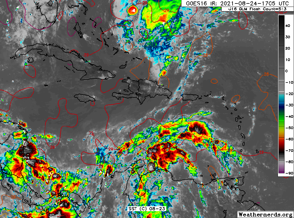
Here’s a closer look at the Caribbean system which is still fairly broad and disorganized. The big swirl up by the Bahamas is an upper-level low, the feature we’re looking at is south of Hispaniola/Puerto Rico. No development is expected in the short-term as the system follows the upper-level low slowly west-northwest.
Later this week, the wave axis will tilt more towards a north-south orientation compared to its current ENE-WSW orientation. This is because the southern end will get “hung up” on Central America while the northern end can keep going towards the NW Caribbean.
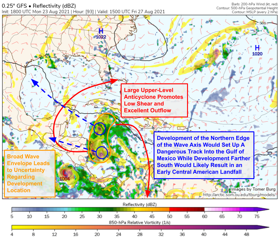
Which part of the wave axis ends up becoming dominant is the critical forecast question for Central America, the Yucatan Peninsula, and the western Gulf of Mexico. One possibility is that the southern end takes over, positioning the system for an early landfall in Nicaragua or Honduras. This would produce potentially devastating flooding in areas still recovering from the double-whammy of Eta and Iota last year. However, it would also limit the window of opportunity for significant development in an extremely favorable environment.
If the northern edge of the system takes off, it will find very hospitable conditions for development. There is abundant moisture, extreme upper-level divergence, and water as hot as it gets in the NW Caribbean. It’s hard for me to see anything stopping a tropical cyclone that develops west of Jamaica Friday. A storm in this area would be steered northwest towards the Yucatan this weekend and into the western Gulf of Mexico early next week.
What happens then is anyone’s guess, but folks from New Orleans west to Texas should be paying close attention to forecasts over the coming days. We’ll know a lot more later in the week once we can see where the system is organizing. As of now, all options are on the table from a tropical wave locally enhancing afternoon thunderstorm activity to much more widespread/significant impacts from a strong tropical cyclone.
The other two systems to watch out in the Atlantic pose much much less of a threat to land.
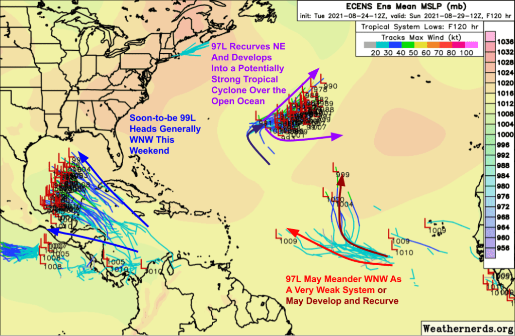
97L sits northeast of Puerto Rico this evening and is drifting slowly NW. Later this week, the system will turn towards the northeast at which point conditions will be more favorable for development. Some ensemble guidance show pretty robust development and intensification, suggesting a hurricane is quite possible. Thankfully it should remain over the high seas though folks in the Azores should keep half an eye out in case it decides to wander that way next week.
98L is farther southeast and has much less ensemble support. Either it will remain weak and continue drifting slowly WNW, or it will develop into a low-end tropical cyclone and turn to the north. Neither possibility is very concerning for land interests, though if it remains weak and continues towards the SW Atlantic we might have to watch it a bit more closely in 7-10+ days.
I’ll aim to have updated info on each system every day or two so long as land impacts remain possible.
-Jack
