Hello everyone!
There isn’t a whole lot of new and exciting info to share about Fred or TD7 this afternoon, but it’s time for our daily check of the tropics so let’s take a quick spin around each system.

After struggling to produce almost any convection this morning, Fred finally has some bubbling to show this afternoon. The caveat is that most of it seems to be driven by diurnal heating over Cuba and it’s falling apart as it moves offshore. The center of circulation appears to be somewhere over Central Cuba, though there are hints that it might be getting tugged/relocated south towards the biggest and most persistent burst of convection.
West of the center, notice the thin white line moving south out of the dying convection over western Cuba. This is an outflow boundary marking the leading edge of rain-cooled downdraft air produced by these storms. Such a feature is a sign that dry air remains lurking nearby and stands ready to pour cold air onto Fred’s plans for reintensification.

For most of today, Fred has been moving just about due west rather than the expected WNW heading. As a result, forecasts have been shifted a bit to the west especially in the short term.
What does this mean? It looks like we’re heading more towards the “TD wanders into the Gulf” scenario rather than the “TS makes landfall in S FL” scenario discussed yesterday. It will still be plenty rainy in southern Florida tomorrow as Fred passes by to the west, but impacts should be limited to localized flash flooding. Some of the western Keys might manage some wind gusts strong enough to disrupt power, but overall this doesn’t look like an especially damaging system.
Another implication is that the new track farther west will extend the window Fred might theoretically be able to intensify over the warm waters of the Gulf of Mexico. That window will last about 48 hours based on current forecasts before the storm makes landfall on the northern Gulf Coast. That said, while the oceanic window might last 48 hours, there might not be much of that time during which atmospheric conditions are favorable for intensification.
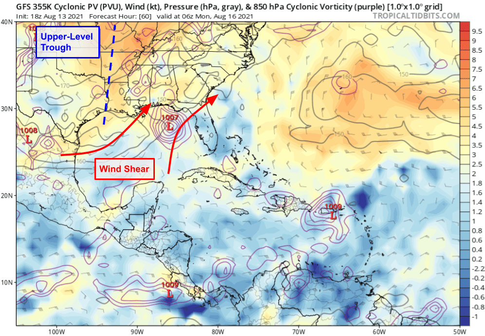
As Fred moves through the eastern Gulf, an upper-level trough will approach from the west. This will have two important effects on the storm: it will steer it to the north, and it will impart southwesterly wind shear. That shear, along with some dry air, will cap Fred’s potential for intensification. As Fred turns north/northeast and starts accelerating a bit, the relative shear (felt by the storm) will decrease for the same reason you don’t feel any wind driving 20mph with a 20mph tailwind. This combined with the warm waters over this part of the Gulf should allow for modest strengthening Sunday and Monday, and the current NHC forecast for landfall as a moderate-strong TS (60 mph) is about what I’d have if I had to pick a number.
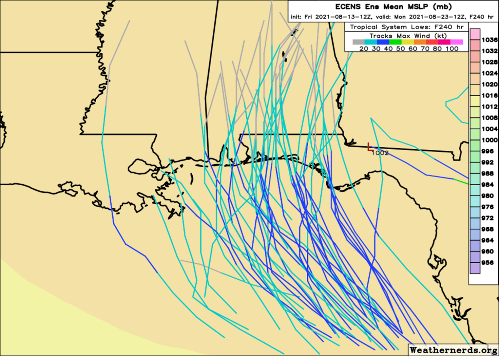
As far as where landfall will occur, I think the EPS ensemble has a pretty good handle on the range of possible outcomes and their relative likelihood. Spots from the MS Panhandle to Apalachicola FL are most likely to see Fred’s center while odds drop off sharply to the east (landfall over or south of the Big Bend looks very unlikely as of now) and more slowly to the west (a LA/MS landfall is less likely than AL/FL but can’t be ruled out). With the southwesterly wind shear pushing thunderstorms northeast of the center, folks to the east of the center’s track will be most impacted by heavy rain and strong winds.
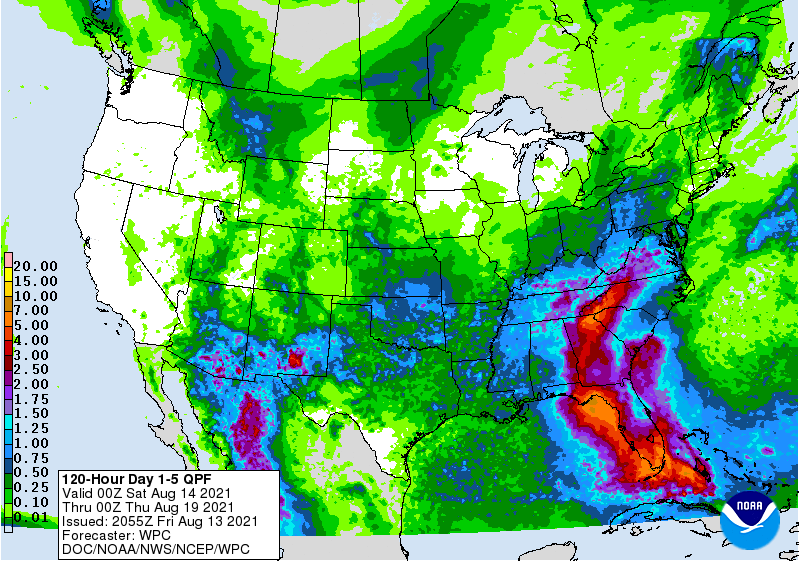
Heavy rain will pose a flash flooding threat all the way up into the southern Appalachians as Fred’s circulation gets picked up by the trough and carried northeast midweek.
Out in the open tropical Atlantic, TD7 is looking quite healthy this evening after having tightened up its circulation enough earlier today to be deemed a tropical cyclone.

Cirrus outflow is now expanding in nearly all quadrants of the storm, with just a bit of remaining resistance to the southeast. This east/southeasterly shear should continue to let up over the coming days as TD7 moves west-northwest. Closer to the center of the storm, bursts of intense convection have been occurring all day and there has been some new activity developing in the NW quadrant recently.
It will be interesting to see how this activity evolves tonight and to what extent it might be able to improve the cyclone’s structure. The going forecast calls for slow intensification over the next few days, but this convection is intense enough to build an inner core if it persists. Should that happen, intensification might happen a bit more quickly.
Just how strong TD7 can get over the next couple days will be important for its long-term prospects.
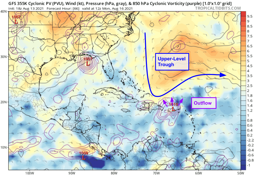
As Fred is dealing with an upper-level trough over the Gulf of Mexico, TD7 will be dealing with its own trough near Puerto Rico. The resulting shear and dry air would likely be near-fatal for TD7 especially if it follows Fred across the mountains of Puerto Rico and Hispaniola. Unlike Fred though, TD7 has the option of fighting back.
If TD7 strengthens enough (strong TS or hurricane) before arriving in the Lesser Antilles, its upper-level outflow would be strong enough to push back on the trough to its northwest. This would allow the storm to maintain an envelope of favorable conditions for maintenance/intensification. TD7’s odds of success in this endeavor are somewhat modulated by the intensity of TS Fred. Fred’s outflow will be acting to build up the ridge pushing this trough southeast towards TD7. The stronger Fred is, the farther SE this trough will be pushed and the harder it will be for TD7 to push it back NW. So there’s a bit of tug-of-war here which adds some extra uncertainty into the forecast.

Assuming TD7 remains on the weaker side, it will continue to be steered west-northwest basically in Fred’s footsteps. If TD7 is a bit stronger, it would start to feel a weakness in the upper-level ridge to the storm’s north on Monday/Tuesday. This would open the door for a track a bit farther to the north as shown in the ensemble forecast above.
Past that, since it’s not even clear TD7 will exist if it runs aground in Hispaniola under strong wind shear, it’s hard to say anything useful about the system’s forecast. But it will generally wander west-northwest in the vicinity of the Bahamas and Florida where impacts, especially heavy rain, are possible during the middle of next week.
-Jack
