Hello everyone!
Neither of our two systems in the tropical Atlantic, TD Fred and 95L, are doing especially well this afternoon thanks to the effects of dry air and wind shear. TD Fred is attempting to start rebuilding its near-core thunderstorms after they were shredded by the high peaks of Hispaniola yesterday.
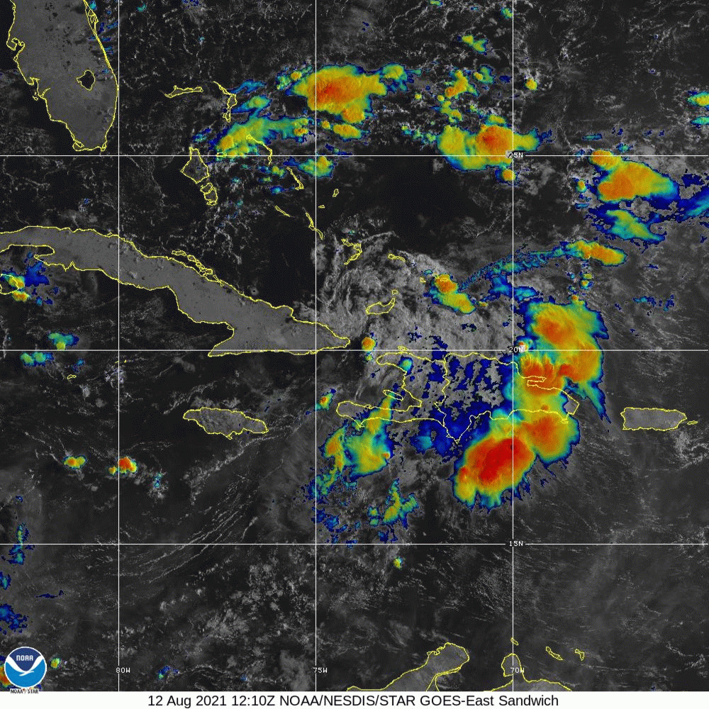
This “sandwich” satellite imagery product is useful because it distinguishes shallow low-level clouds (white/gray) from deeper thunderstorm activity (yellow/red). Fred has had a lot more of the former than the latter since making landfall in Hispaniola yesterday, though some activity seems to be redeveloping especially east of the center this evening. The preferential redevelopment of convection in the storm’s eastern semicircle is due to westerly wind shear imparted on the storm by an upper-level low over Florida.
We’ve talked a lot about this low over the past few days, and there isn’t much more to say at this point. The low will gradually weaken as it retreats back into the southeastern US this weekend, but its west-southwesterly winds and dry air will continue to impact Fred until the storm makes landfall in Florida.
This low, combined with Fred’s current state of (dis)organization means our going forecast of a weak to perhaps mid-strength TS impacting southern Florida Saturday still looks good.

Ensemble guidance is singing a pretty similar song today as it was when we last checked yesterday. Given Fred’s struggles today, the scenario of a strong TS curving north a bit earlier seems pretty safely off the table. The most likely scenario remains landfall in the Florida Keys or the southern Florida Peninsula as a weak TS (or perhaps even TD), though it’s also possible that the system remains extremely disorganized and slides west of Key West.
It’s possible that Fred will turn north/northwest just after landfall in southern Florida in which case it would probably dissipate over the peninsula while bringing very heavy rain especially to Florida’s east coast. A more likely outcome is that Fred will slide into the eastern Gulf where conditions might be more hospitable for intensification. Some ensemble members show Fred intensifying into a moderate or even strong tropical storm if it can remain far enough off the Florida coast and can fend off continued southwesterly wind shear. Neither is a guarantee, but it’s a possibility worth keeping an eye on for residents from Tampa north to Tallahassee and west towards MS/AL.
I think the western edge of the range of possible outcomes for Fred’s central track is somewhere around Mobile Alabama, but folks as far west as New Orleans might pick up some gusty showers Monday. Overall, unless upper-level winds relax enough to allow for a period of intensification occurs in the Gulf, Fred seems like it will remain a fairly weak system from a wind/surge perspective. Rainfall will unfortunately be another story.
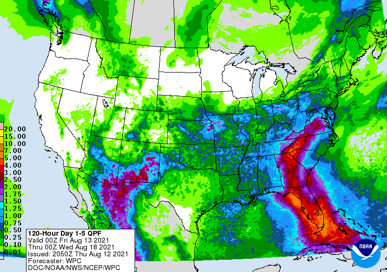
WPC rainfall forecasts show 4-6″ of rain expected across most of Florida all the way inland into GA/SC/NC where Fred or what’s left of Fred will wander early next week. Flash flooding is likely in these areas depending of course on where exactly rain bands set up and hang out. If your area is susceptible to high water during heavy rain events, now is the time to take appropriate action to mitigate those impacts.
Out in the open Atlantic, 95L continues to move westward and hasn’t yet decided where it wants to put its center.

After activity simmered down a bit this afternoon, thunderstorms have been redeveloping this evening near both the northern and southern areas of spin associated with the wave. Satellite-derived wind data suggested that the northern area was pretty close to closing off a circulation this morning, but there’s still a bit of rotation in both the low- and mid-levels down south.
Based on that wind data from this morning and satellite trends this afternoon, I think if we see a circulation close off in this wave it will be up north. This will have some important implications from a track perspective, and by association for the intensity forecast.

This map shows wind shear anomalies across the Atlantic during the time when 95L will be moving through the Caribbean. There are three general possibilities for the system’s track through this area: through the Caribbean Sea, over the Caribbean Islands, or through the SW Atlantic. The first possibility is probably the least likely, but it would provide the system with the best environment for intensification with lower wind shear and warm waters. What’s most likely at this point is probably a track very similar to PTC6 and Elsa through the northern Lesser Antilles before heading towards Hispaniola. Though this would probably favor the least intensification due to land interaction, flooding rain would be a big concern for the Caribbean islands. It’s also possible that the system tracks farther north through the SW Atlantic. While there’s plenty of warm water here, preliminary indications show the potential for more wind shear which would hamper its ability to intensify.
That brings us back to the system’s current dilemma between developing the southern edge of its wave axis or the northern edge. If the northern edge continues developing, we’d really be talking about either a track over or north of Hispaniola. If the southern center emerges victorious, the Caribbean scenario would be on the table as well as interaction with the Greater Antilles.
Until this dilemma is resolved, probably tomorrow or Saturday as the wave slows down and moves over warmer waters allowing for convection to consolidate, there isn’t too much else to say about 95L’s long-term forecast. The odds, as per usual, are somewhat stacked against major development but it’s hurricane season and we have a disturbance moving over warm water in the direction of land so we’ll keep a close eye on it.
-Jack

Good morning Jack, As always a great analysis of the current sitrep re the season. Was looking at Dr. Cowan’s tidbits site this morning which posted the latest GFS run. Which shows Invest 95L going big time. Last night’s run had a major league hurricane making landfall over the Chesapeake Bay while this morning’s now shows what appears to be a high end Cat 2 attacking the GA-SC border sometime near Tuesday 24-August. Will await your analysis… Thanks for doing great work !
LikeLike