Hello everyone!
We have two systems on the agenda for discussion this afternoon: TS Fred (formerly PTC6/Invest 95L) currently crossing the island of Hispaniola and Invest 95L which is moving west across the open tropical Atlantic. The former is already bringing impacts to land areas and thus will be our primary focus.

Satellite imagery this afternoon shows Fred’s center crossing through central parts of the Dominican Republic. This is consistent with the southern path outlined in yesterday’s post as being more likely. This path has taken Fred’s center over the highest mountains Hispaniola has to offer, well over 10,000 feet, the friction from which will significantly disrupt the storm’s circulation. As a result, expect the storm to be downgraded to a Tropical Depression later tonight. It is more likely than not that the center of circulation will cease to be well-defined, so it’s possible Fred might not even be a tropical cyclone when it emerges off the north side of Hispaniola early tomorrow morning though NHC may opt to keep the name for the sake of messaging consistency (un-naming then re-naming the storm shortly thereafter would cause confusion).
Fred will have to rebuild almost from scratch starting tomorrow morning. This process is usually slow under the best of atmospheric conditions, and Fred won’t have that benefit.
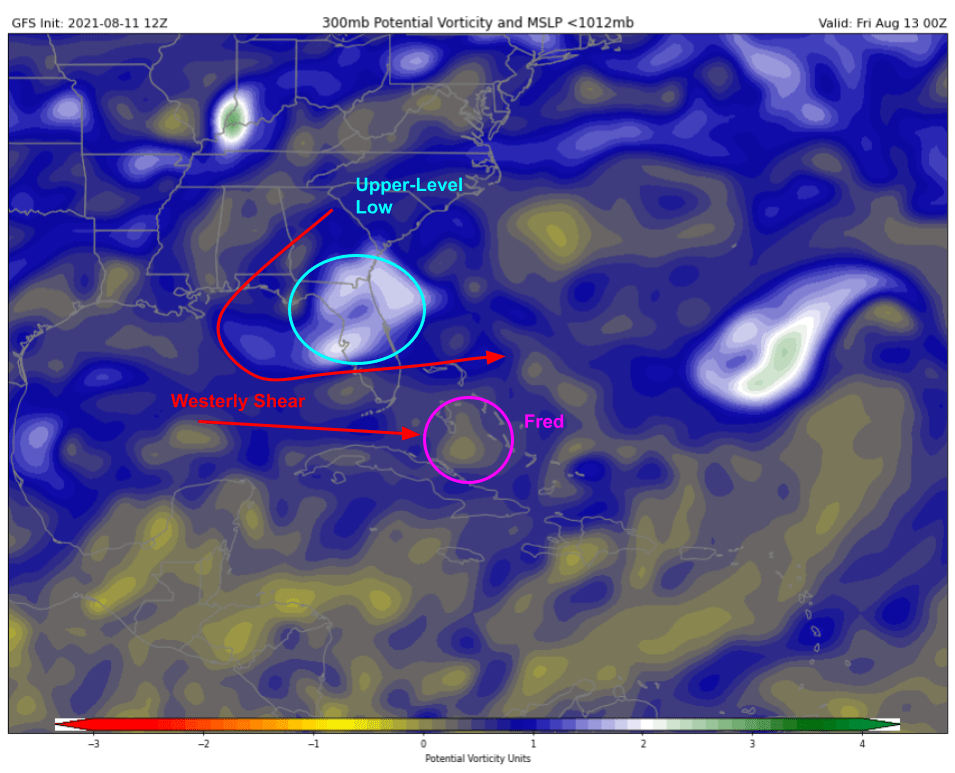
Fred is already starting to face some westerly wind shear from an upper-level low posted over Florida. That shear will only get stronger as Fred continues to push west-northwest over the next 24 hours. Overall, the forecast thinking here hasn’t changed much from yesterday: Fred should regain some strength over the warm waters surrounding the Bahamas but probably won’t be able to intensify past low-mid grade tropical storm strength due to the shear.
Ensemble guidance gives a good overview of what to expect and where uncertainties lurk.

The near-term track forecast is pretty much locked in thanks to steady steering currents on the southwestern edge of the Bermuda High. Fred will continue moving west-northwestward today, tomorrow, and Friday as a disheveled TD/TS. The storm’s intensity Friday night will determine what happens Saturday. Most likely, the storm will be a weak-mid grade TS moving more towards the NW into the Florida Keys or the far southern Florida Peninsula. If Fred is a little weaker (I’d peg the odds at about 1-in-5 that it never regains a circulation after Hispaniola), it would slide farther west into the Gulf of Mexico. If Fred is a little stronger (not likely, but can’t totally rule it out), it would turn more towards the north and could head up Florida’s east coast.
The impact factors for each scenario are actually quite similar. South Florida and the Bahamas will get gusty squalls from thunderstorm activity pushed east of the center by that westerly shear no matter where exactly it tracks. Perhaps a few unlucky beaches in southern FL could rack up a 40-50mph wind gust if the storm can get back going again and make landfall, but that’s not exactly worth losing much sleep over. Heavy rain remains the primary threat from Fred for Cuba, the Bahamas, and southern Florida.
On Sunday and Monday, Fred will begin to turn towards the north wherever it is. If this happens over the Florida Peninsula, it might just dissipate over land leaving a few gusty showers in its wake but little more. If this turn happens over water, either in the Gulf (more likely) or the Atlantic (much less likely), a period of more notable intensification would be possible as the upper-level low weakens. Right now, only a few ensemble members depict such intensification, and almost all of those that do keep the storm shy of hurricane status. I suspect we won’t know too much about this phase of the storm’s evolution until Saturday when it’s clear where this turn will happen and perhaps what the upper-level environment will look like.
As we get farther into August and a large scale pattern more favorable for Atlantic tropical cyclones, it’s no surprise that we’ll have more disturbances to discuss. Sure enough, there’s a tropical wave about half way between Africa and the Caribbean that merits some attention this evening.

Satellite imagery shows this feature, dubbed 95L for the purposes of getting some more information on it, producing a healthy amount of thunderstorm activity nearly comparable to TS Fred.

Upon closer inspection though, 95L has some work to do before it earns a name. The low-level rotation associated with the wave is displaced a bit northeast of the mid-level rotation and deeper convection. This is partly due to its relatively brisk forward motion (the lower part of the wave is getting “left behind”) and partly due to some shear from thunderstorm outflow in Africa. As the disturbance moves west, it should slow down a bit and as it gets farther from Africa the shear should lighten up too. As an added bonus, you can see on the map above that sea surface temperatures get warmer as you move farther west. So while the odds of development are pretty low in the short-term, once 95L approaches the Lesser Antilles this weekend, the stage should be set for better organization.
Just how organized 95L is on approach to the Lesser Antilles will have a big impact on its long-term prospects.
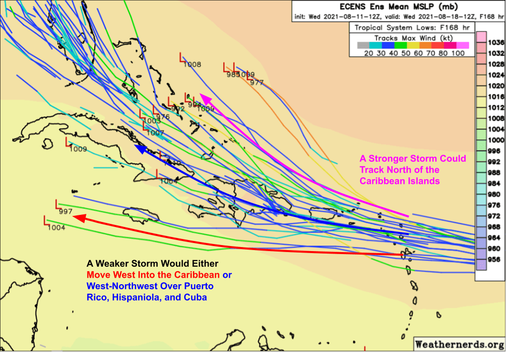
A stronger storm would “feel” winds higher up in the atmosphere with a bit more of a southerly component. That would turn the system a bit more towards the northwest, possibly sending it north of Puerto Rico and Hispaniola. This would be a potentially ominous scenario, opening the door for a strong system moving into the Bahamas/SW Atlantic, though it’s too early to offer any speculation on impacts in Florida or along the US East Coast.
A more likely scenario is that 95L will approach the islands as a disturbance, TD, or weak TS. In this case, a track similar to Fred’s towards Puerto Rico/Hispaniola would be favored, though it’s not impossible to see the storm continuing west into the Caribbean Sea. While a track over the islands would keep the system’s intensity in check, it would open the door for potentially significant flash flooding especially given how saturated soils will be following Fred.
At the moment, there isn’t too much else to say about 95L except that it’s one that we’ll probably be talking about for a little while.
I’ll keep aiming to post daily updates so long as these (or other) systems pose a threat to land.
-Jack
