Hello everyone!
Invest 94L became Potential Tropical Cyclone 6 yesterday afternoon as it passed through the Lesser Antilles. This change in designation means nothing meteorological, but it allows the NHC to issue watches and warnings even though the center hasn’t quite finished developing yet.
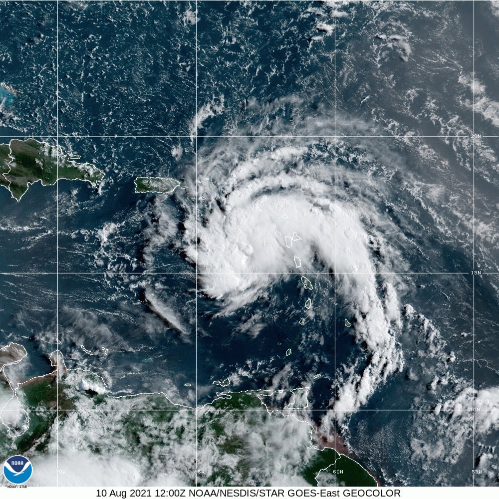
PTC6 looks very healthy on satellite imagery with curved banding features present northwest, north, and northeast of the center. Cirrus are streaming out away from the center unimpeded by any upper-level wind shear. On the other hand, dry air lurks south and west of the center which is interrupting thunderstorm activity in those parts of the storms.
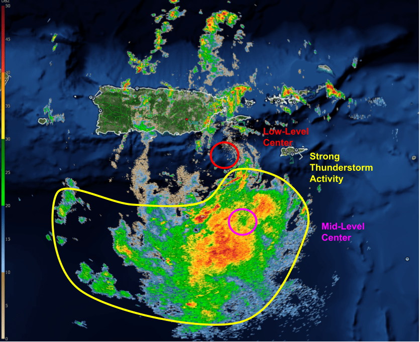
Radar imagery from Puerto Rico can help investigate what’s going on under and inside the clouds. Despite the very photogenic appearance on satellite imagery, PTC6 has some serious work to do under the hood. The low-level center appears to be emerging just off the SE tip of Puerto Rico while the mid-level center sits a bit farther to the south in the midst of some stronger thunderstorm activity. The cause of this discrepancy isn’t immediately clear to me, but it is helping to hold the system in check this evening.
Impacts tonight in Puerto Rico look to come mostly in the form of heavy rain and potential for flash flooding. PTC6’s fast forward motion should help limit the damage, though in complex terrain it doesn’t take long for significant rain, and significant flooding, to develop.
The disconnect between PTC6’s low- and mid-level centers is also producing some significant forecast uncertainty. Which center becomes dominant and when will determine the system’s strength over the next few days as it moves towards the Dominican Republic, the Bahamas, and eventually Cuba/Florida. As the storm is steered WNW by a strong ridge to the north, it will move towards the island of Hispaniola tonight. How exactly the storm interacts with the island will be critical in determining the extent of impacts farther downstream.
While Hispaniola has a well-deserved reputation for shredding tropical cyclones that pass over it, the island is not an equal-opportunity disruptor.

Here’s a topographical map of Hispaniola with two possible tracks for PTC6 outlined in red and pink. The red track is about what is projected by the NHC and most model guidance, and would take the circulation’s center directly over mountains as high as 10,000 feet. The friction associated with these mountains would significantly disrupt the cyclone’s circulation, possibly eliminating it altogether (if it ever fully develops by the time it makes landfall). In this scenario, PTC6 would need to rebuild from square one, a task that would make significant intensification prior to Florida very unlikely. This scenario, as of now, is the most likely outcome, especially if the LLC near Puerto Rico doesn’t end up becoming dominant.
Another possibility is that this new LLC sets the storm on a course as little as 30 miles farther northeast. This would move the storm’s center over northeastern Hispaniola characterized mostly by plains and low rolling hills. The circulation would still be cut off from its primary energy source (warm water) and would face some friction from the land, but it would stand a much better chance of emerging off the island intact. This scenario, while less likely than the one outlined above, is plausible and may result in a stronger system moving into the Bahamas Thursday.
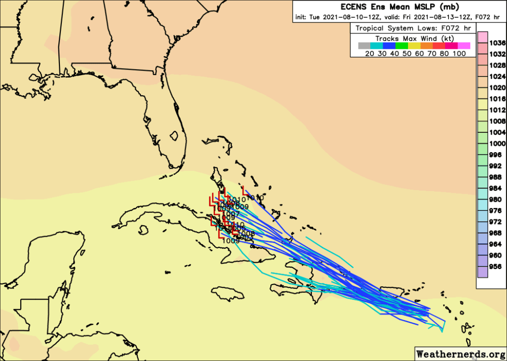
Both scenarios are well-represented in ECMWF ensemble forecasts, though visually spaghetti plots like this give the illusion that the latter (stronger) is more likely given that the members forecasting a track over central Hispaniola lose the storm in the tracking algorithm and so don’t display anything.

Even after Hispaniola, it won’t be entirely smooth sailing for PTC6. As discussed earlier in the week, an upper-level low will be standing guard over Florida, ready to impart westerly wind shear on any tropical cyclone daring to threaten the state. This low isn’t especially strong, so if PTC6 emerges off Hispaniola with a reasonably intact circulation and robust thunderstorm activity, it may not be slowed down too much by the upper level low. However, if the storm needs to rebuild its low-level circulation from scratch, this wind shear could be a significant impediment. This is partially why figuring out PTC6’s condition post-Hispaniola is so key to the medium-range forecast. Right now, I’m still leaning towards the weaker solution. Storms can reorganize off Hispaniola, and they can fend off wind shear, but doing both at the same time is a much harder line to walk.
Whatever happens with the storm’s intensity during this time, the same ridge will continue pushing PTC6 west-northwest towards Florida.

The consensus ensemble forecast for Saturday morning shows PTC6 nearing southern Florida as a weak to perhaps mid-grade tropical storm. This is where my money is too. Some exposed coastal sites may pick up some minor wind damage from 45-55mph winds, and the storm’s outer bands could always produce a tornado capable of more significant but highly-localized damage. That said, the big story will really be heavy rain. As with Puerto Rico, the storm’s steady pace will limit chances for extreme flash flooding, but it doesn’t take much time for tropical rain rates to cause issues.
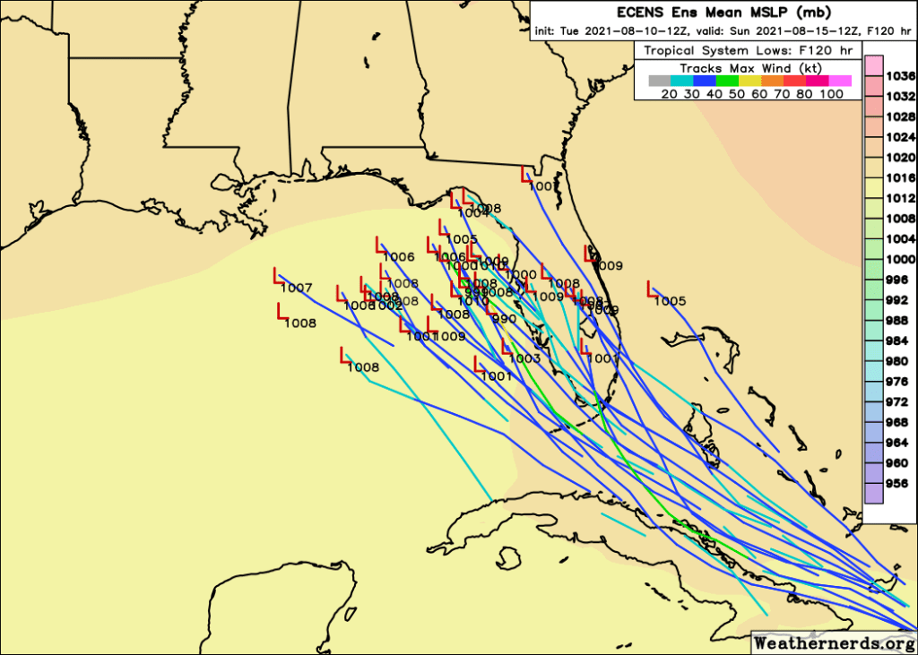
After moving near or over southern Florida, PTC6 should gradually take a turn off towards the northwest/north as the subtropical ridge weakens. This is about 4-5 days out, so the exact timing and location of this turn is still to be determined. If the turn happens faster, the storm would track up the Florida Peninsula mostly bringing heavy rain as it slowly fizzled out. A slower turn could send the storm into the Gulf of Mexico where some strengthening would be possible depending on how fast that upper-level low can get out of the way.
Folks from New Orleans east to Jacksonville should be keeping a close eye on PTC6 as future forecast updates will determine whether any action needs to be taken ahead of potential impacts this weekend. As of now though, my money is against much significant strengthening.
I’ll aim to have an update out each of the next few days as the forecast for Florida becomes clearer. As a reminder, my thoughts are entirely unofficial and when making decisions about how/when to prepare for a storm, you should consult with official NHC information.
-Jack
