Hello everyone!
In my last update, I mentioned two areas to watch for possible tropical cyclone development this week: one off the North Carolina coastline and the other in the southern Gulf of Mexico. Sure enough, the system off NC ended up becoming TS Bill and 92L in the Gulf of Mexico appears very likely to develop into the third tropical storm of the season in the next couple days. With Bill having disintegrated into a non-tropical low a couple days ago, our focus can now shift entirely to the system in the Gulf.
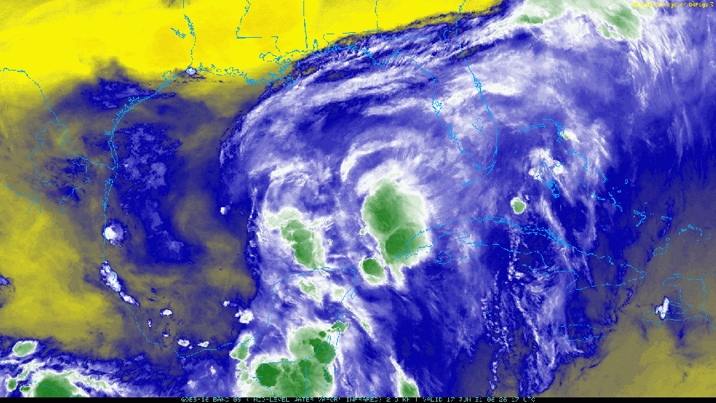
WV satellite imagery over the area shows a large area of disorganized convection to the east of an upper-level low over the western Gulf of Mexico. Where exactly 92L is embedded within this larger swirl is up for some debate.
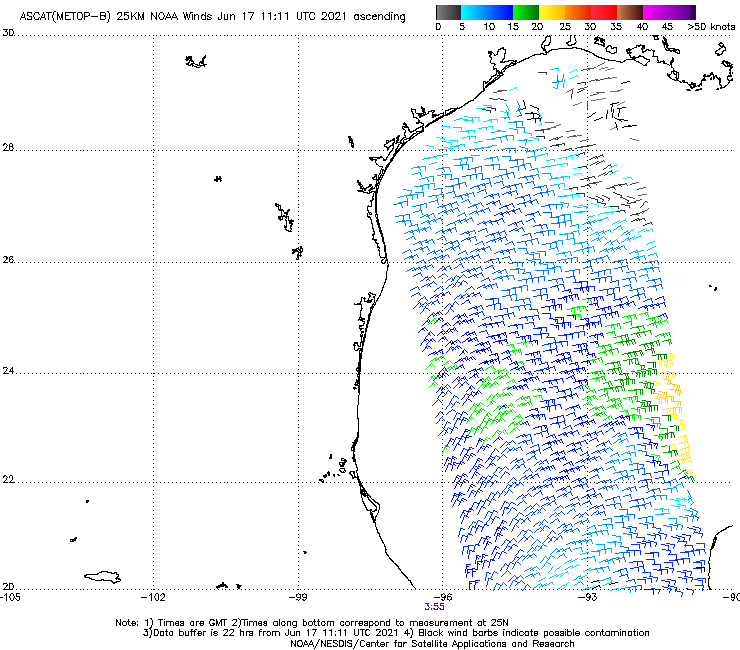
Satellite-derived wind estimates show broadly cyclonic flow (counterclockwise rotation to the winds) over this area, but there’s no clear center of circulation where winds rapidly shift from SE to NE to NW to SW. If you look closely though, there’s a subtle wind shift over the Central Gulf near about 92W/23N.
That wind shift, marked on this image with the red line, is near some recent thunderstorm development but east of the deepest convection near and north of the Yucatan. One possibility is that the center of circulation tries to emerge somewhere around here, roughly underneath the mid-level swirl you could see on WV imagery earlier in this post. The primary limiting factor here is the lack of deep convection (intense thunderstorm activity) in this area relative to the storms near/north of the Yucatan. To get that mid-level spin to translate to a center of circulation at the surface, you need intense thunderstorms and the dry air you can see mixing into that side of the circulation on the WV imagery is inhibiting the development of that more intense thunderstorm activity.
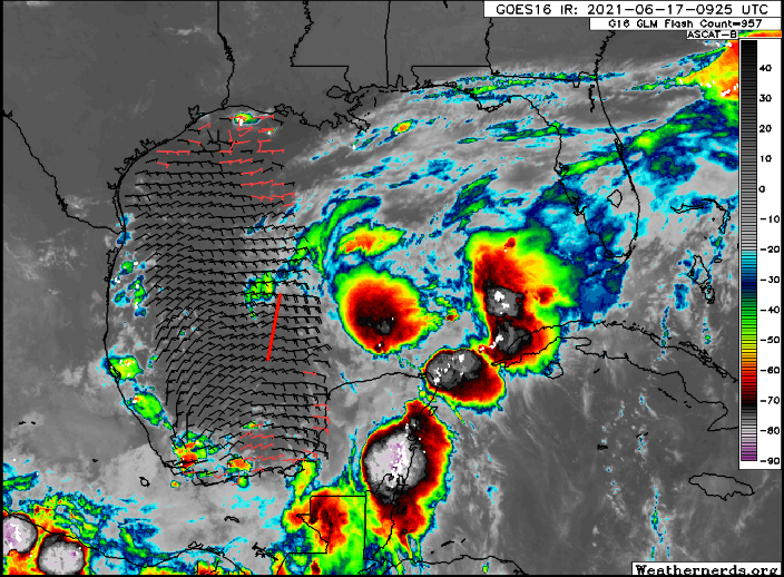
Another possibility is that 92L’s center will emerge farther east, under those deep thunderstorms off the Yucatan. This is what most model guidance seems to be picking up on, though there’s still plenty of uncertainty given how much easterly momentum would need to be reversed for the system to close off a center of circulation here.
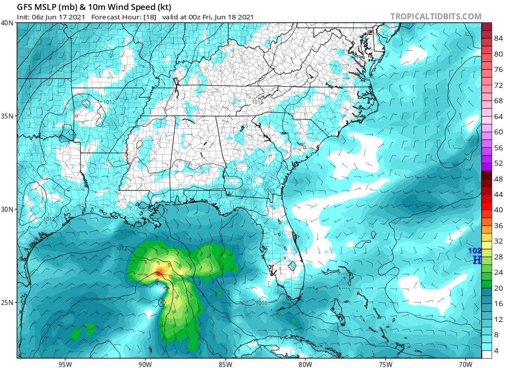
In this GFS forecast frame valid this evening at 7 PM CDT, you can see 92L’s tight circulation emerging south of New Orleans and northeast of the broader low/trough over the Bay of Campeche. Given the prevailing easterly flow in this area, it will take some effort for 92L to produce ground-relative westerly winds in order to close off its center of circulation, but with enough deep convection it could certainly get the job done.
Where is the system headed?

While 92L’s exact track will be determined largely by where the center decides to develop today, the general idea is that the storm will be steered generally north by an upper-level trough over Texas. Initially, the storm will probably move a bit west of north as it’s embedded within the broad southeasterly low-level flow around the trough in the Bay of Campeche. As the circulation strengthens a bit, it will be able to feel the influence of the TX trough a bit better and thus will turn back to the north/northeast.
While there’s still some uncertainty about where exactly the center will track, I’d urge everyone not to focus much if at all on the storm’s center. Unlike most tropical cyclones, the area near the center of 92L is likely to be among the least impacted.
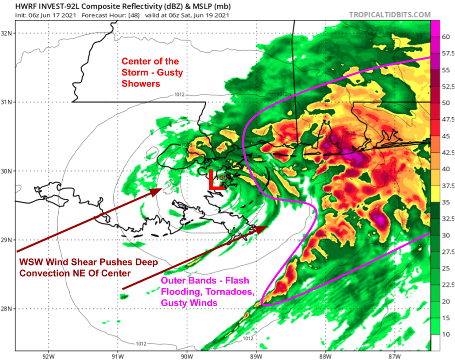
This is because moderate to strong WSW wind shear will be pushing most of the system’s intense thunderstorm activity away from the center and towards the northeast. So while areas near the center will see gusty showers, the flash flooding and tornadoes most likely to cause serious damage will be found dozens or even hundreds of miles to the northeast.
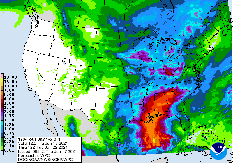
Keeping in mind that the center of 92L is most likely to make landfall over central LA, the WPC precipitation forecast does a good job highlighting the discrepancy between the central landfall location and the most severe flooding impacts which will be felt from New Orleans east to the FL Panhandle. Flooding rains of 3-6″+ could extend as far inland as TN and NC depending on how well the system holds together as it accelerates off to the northeast.
Overall while 92L is not likely to become a strong tropical cyclone, it will bring some notable impacts especially north and east of the center. Now is a good time to start preparing for flooding impacts from SE LA east to the FL Panhandle and north to TN/NC. Rain will begin falling tomorrow afternoon as the storm approaches from the south and will continue through Saturday and into Sunday as the system moves steadily north/northeastward.

Elsewhere in the Atlantic basin, all is quiet as Saharan dust limits thunderstorm activity across most of the tropics and a cold front off the East Coast has enough cold air behind it to remain non-tropical.
-Jack
