
Hello everyone!
The 2021 Atlantic hurricane season has been off to a wildly active start as we’ve burned through four names already (Ana, Bill, Claudette, and Danny) with number five, Elsa, imminent in the deep tropics. For comparison, at this time last year, we had also run through four names on the list with number five not coming until the evening of July 5th.
The primary feature to watch in the Atlantic as we close the books on June and head into July will be a developing tropical cyclone well southeast of Barbados. As of the 5 PM EDT update from the NHC, this system is not yet a tropical cyclone but has been given the “Potential Tropical Cyclone” designation to allow for the issuance of tropical storm watches and warnings in the Lesser Antilles.

We’ll start our analysis, as always, with a look at satellite imagery. There are two areas of shower and thunderstorm activity that stick out over the tropical Atlantic this evening. The western blob, over the Lesser Antilles now, is Invest 95L which the NHC gives a low chance of development over the next 5 days. It is bringing heavy rain and gusty winds to the islands currently and will continue to do so as it moves west-northwest over the coming days.
The primary feature of interest, PTC5, is located farther to the southeast. It’s sitting in a pretty favorable environment for continued organization with low wind shear (note the cirrus fanning out from the center of the system) and dry air displaced fairly far to the northwest. The introduction of some of that dry air might be why we haven’t seen thunderstorm activity as intense or consistent as would be needed for the formation of a tropical cyclone.
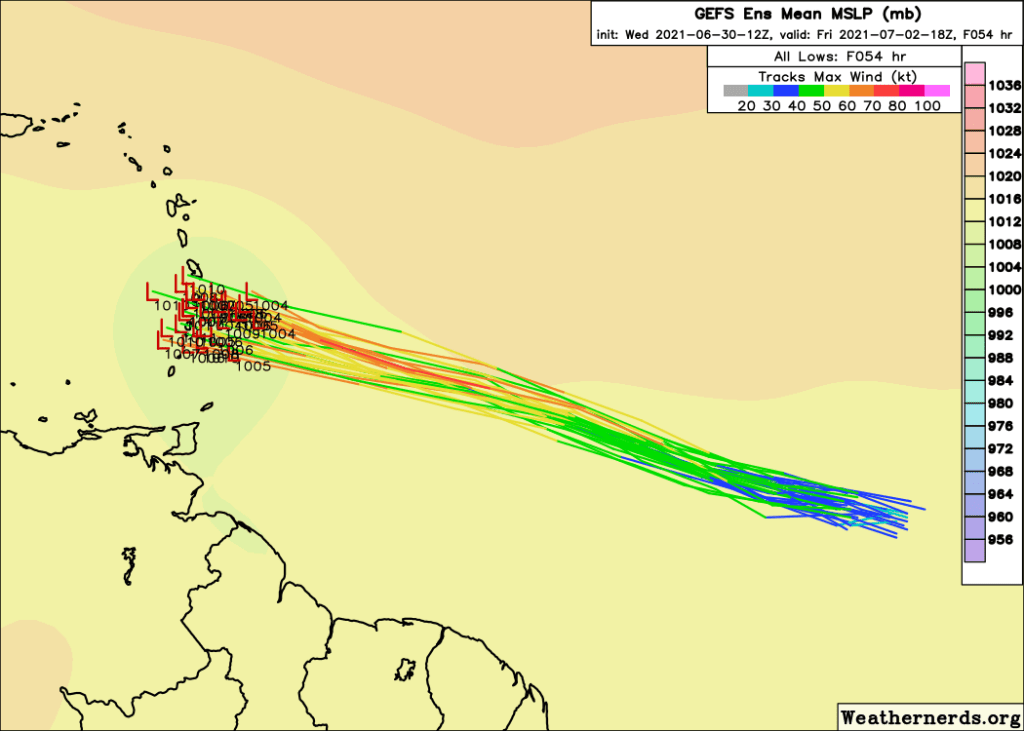
PTC5’s short-term forecast is pretty clear. It will be moving west-northwest driven by flow around a strong Bermuda High dominating the subtropical Atlantic basin. Ocean temperatures under the storm will increase from around 27C to around 28C which is more than supportive enough for development. Depending on how quickly thunderstorm activity can get going tonight/tomorrow, I’d expect to see PTC5 approach the Lesser Antilles as a moderate to strong tropical storm by Friday afternoon. Impacts to the central and southern islands will include gusty winds and heavy rain with the potential for mudslides and flash flooding, especially given “priming” of the soils by rain from 95L today.
After PTC5 departs the islands, the forecast becomes a bit more uncertain.

The strong subtropical ridge/Bermuda High (denoted on the map in orange) will push PTC5 into the Eastern Caribbean, but the exact strength of the western periphery of the ridge is still a bit unclear. If the ridge is stronger, expect the storm to track more to the west over the open waters of the Caribbean Sea. A weaker ridge would favor a more west-northwesterly track towards Haiti.
The strength of the ridge looks to be largely modulated by the depth of a trough over the US East Coast this weekend. A stronger/deeper trough would be able to do a better job of chipping away at the ridge and drawing PTC5 north.

The trend in model guidance over the past couple days seems to favor a weaker ridge, though there is a well-known bias in the GFS model and its ensembles to underdo the strength of the ridge in this part of the world, so there is some reason to keep the door open on the more southern tracks for now.
While there is some uncertainty in the track forecast, there is a lot of uncertainty in the intensity forecast.

As the storm moves into the Eastern Caribbean, it’s going to run into some roadblocks for potential further intensification. The most notable roadblock for storms in this part of the world especially at this time of year is the strong trade winds that dominate much of the Caribbean Sea. The divergence in the lower levels created by these trade winds running away from the clockwise flow around the Bermuda high will make it harder for PTC5 to sustain convective activity which relies in part on low-level convergence.

The strong trade winds near the surface also look to induce some west/northwesterly shear thanks to the contrast with weaker flow aloft. This should also keep a lid on PTC5’s intensity both by lumping most of its convection east of the center (which will likely be outrunning its attendant thunderstorms) and by introducing some dry air lurking to the northwest of the circulation.
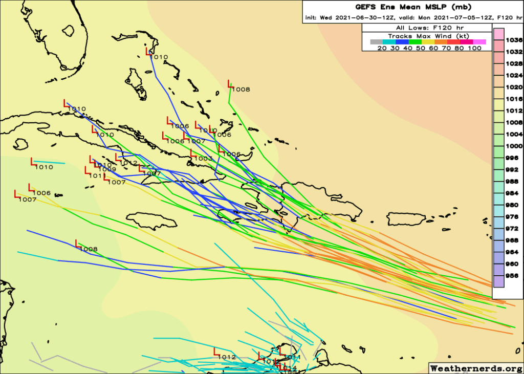
Another reason to be skeptical of PTC5’s intensity potential in the medium-range is interaction with the tall mountains of Hispaniola and Cuba. Even the most aggressive GEFS members which show PTC5 becoming a hurricane in the eastern Caribbean (possible albeit not the most likely outcome) indicate the potential for rapid weakening as the storm moves over land. If PTC5 can stay farther south and avoid a landfall in Hispaniola or Cuba this weekend, it would have a better shot at maintaining its identity as a tropical cyclone.

By early next week, PTC5 or its remnants will be somewhere in the vicinity of the southern Gulf of Mexico, Florida, or the western Atlantic ocean. This means folks in Florida and the Bahamas should stay tuned into forthcoming updates on the system as impacts are possible. That said, this system has a lot of road blocks to overcome before it becomes something worth seriously worrying about. It’s true that some model guidance shows the potential for PTC5 to become a hurricane at some point during its life cycle but dry air, wind shear, divergence near the ground, and interaction with land will all be fighting to keep the system on the weaker side.
At the moment, I think the primary impact from PTC5 west of the Lesser Antilles will be heavy rain and associated flooding/mudslide risks. If this changes, possibly due to changes in the storm’s forecast track, you’ll hear about it in plenty of detail here.
I plan to do daily updates on PTC5 as long as the system poses a potential threat to the US. For more frequent updates from me, you can follow me on twitter @JackSillin. Remember that I am just a student and should not be considered a source of official information to be used for making critical decisions. Official information from the NHC can and should be consulted at nhc.noaa.gov. Graphics in this post come from tropicaltidbits.com, weathernerds.org, and CIRA.
-Jack
