Hello everyone!
While we humans have assigned June 1st to mark the beginning of the North Atlantic Hurricane Season each year, Mother Nature follows her own schedule. This year, it appears as though she’s ready to kick off the 2021 Hurricane Season starting this week, though we’ve already snuck a name off the list with Subtropical Storm Ana forming back in May.
There are two systems I have half an eye on today, and this post will quickly examine each as well as take a look at the state of the broader Atlantic and what clues it might give us about the weeks and months to come.
Overview
As always, we’ll start with a look at satellite imagery across the basin.

On this imagery, yellow/salmon/pink colors represent thunderstorm activity or cirrus while light blues represent low clouds and the milky light blue over the central Atlantic represents Saharan dust. As you can see, that dust layer (known colloquially as the Saharan Air Layer or SAL) is keeping a strong lid on thunderstorm activity across most of the tropical Atlantic. Closer to North and Central America, there are two subtle areas of spin located near some thunderstorms. These are the two systems we’ll be thinking most about over the coming week.
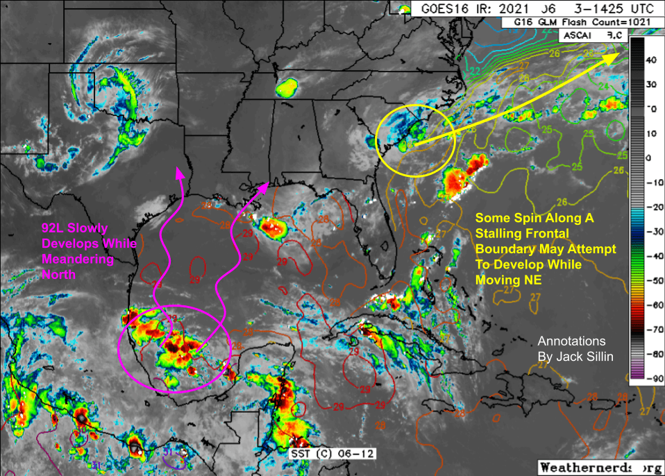
Here’s a slightly different view of these systems showing cloud top temperatures to better highlight the most intense thunderstorms. The cluster of storms over the Bay of Campeche has the best shot at developing into a tropical cyclone over the coming days, and has been given the designation “Invest 92L” by the National Hurricane Center. This designation just means that they’re interested enough in the system to want some extra tools with which to monitor its development. Another system sits off the coast of South Carolina where intense thunderstorms yesterday have added a little spin to a stalling cold front off the East Coast.
92L
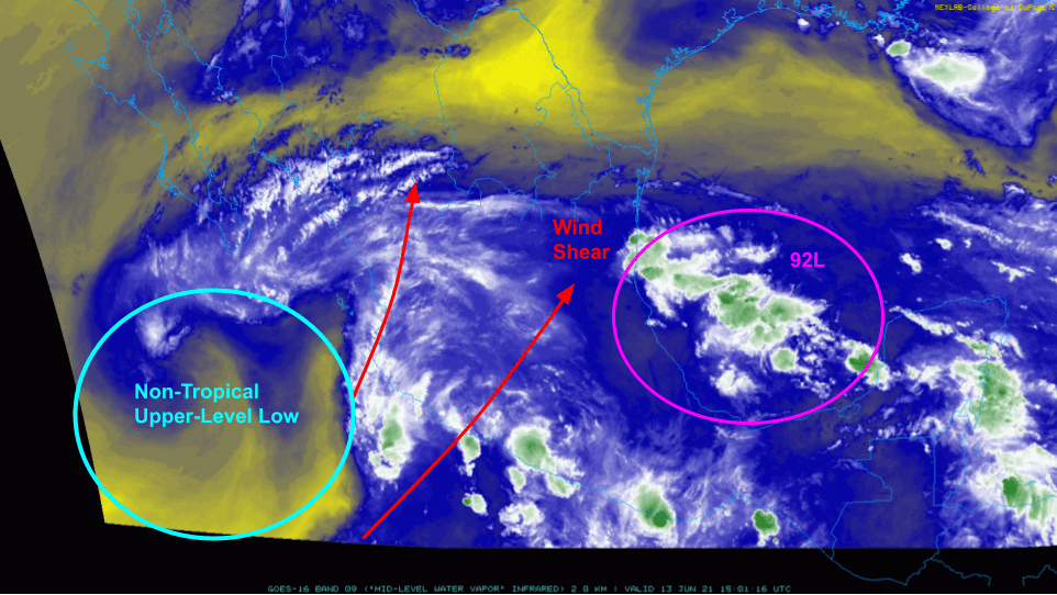
Water vapor satellite imagery of 92L and its surroundings shows the system’s environment dominated by a non-tropical upper-level low to its west. Because this feature is non-tropical, it boasts counterclockwise winds at all levels of the atmosphere (this is different from hurricanes which spin the other way near the top of the atmosphere). The southwesterly winds aloft provided by this low will impact 92L in two important ways: it will steer the storm gradually to the north or perhaps north-northeast, and it will make the consolidation of a tight inner core of intense thunderstorms more difficult.
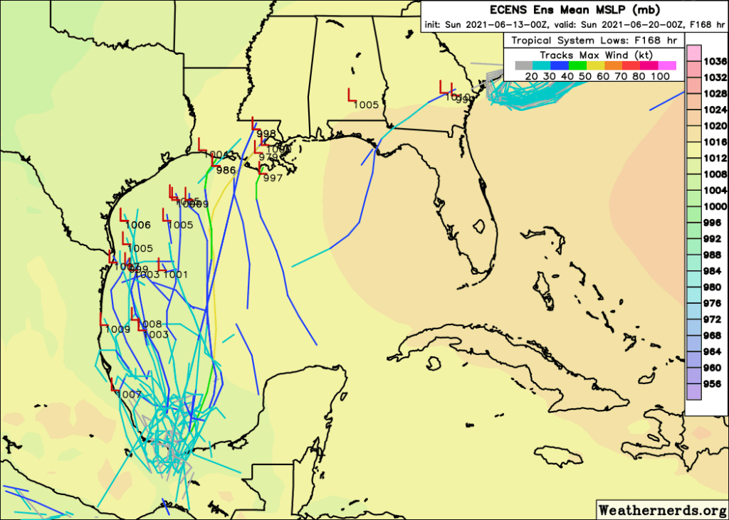
Most ensemble member forecasts for 92L confirm the forecast intuition we developed from that satellite image. Most members show at least some development of the storm as it wobbles ever so slowly north. All the little “L”s on the map show one possible spot the storm could be in a week. Also note that most of the members keep the storm rather weak, with max winds somewhere between tropical depression (20-30kts) and moderate tropical storm (40-50kts) strength. At this point, 92L looks unlikely to become a hurricane, though it’s still a smidge too early to entirely rule out that possibility.

For all the caveats that should go along with a GFS forecast frame more than seven days out (I very rarely post these for a reason), I think this forecast does a pretty good job outlining what I think is the most likely outcome from 92L. I think it will develop into a tropical storm over the coming week while meandering gradually north over the already-warm Gulf of Mexico. Where the storm’s center goes is not yet clear to me, but somewhere between Houston and New Orleans seems most likely. The gustiest winds potentially capable of some power outages will be found within 50-100 miles of the center, mostly on the eastern side.
That said, the biggest threat from 92L and the storm it will eventually become is heavy rain. As the forecast map above highlights, bands of heavy rain will likely be pushed hundreds of miles east of the storm’s center by those upper-level winds we talked about earlier. So even if you’re in MS/AL/FL, you should start thinking about what you might need to do to prepare for some flooding should forecasts continue to indicate the potential for several inches of rain sometime next weekend.
East Coast Disturbance

Thunderstorms that impacted parts of South Carolina yesterday have wandered out into the Atlantic this morning and have added a bit of spin to a stalled frontal boundary just offshore. You can see the band of showers and storms just off the SC coast spinning a bit on satellite imagery above. This is the time of year we watch for little areas of spin like this to develop into short-lived tropical cyclones as they move northeast over the Gulf Stream.

Sure enough, there is pretty solid ensemble support for the development of a storm from this system over the next few days. As the system moves northeast, it should intensify, but it remains to be seen whether or not it can become sufficiently organized to be deemed a tropical or subtropical cyclone. The same feature steering it quickly northeast will be imparting some shear on the storm, and ocean temperatures aren’t exactly boiling here yet. That said, we saw many storms form in this area in this manner last year, so it’s worth keeping an eye out even though impacts to land will be negligible (perhaps a little boost to the surf along the Outer Banks).
Rest of the Basin
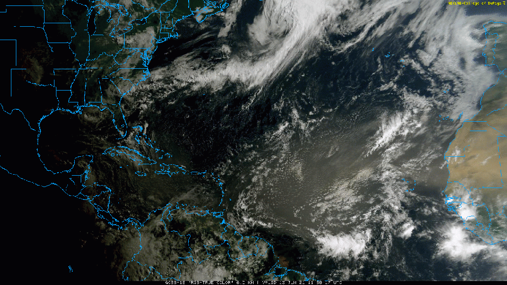
Elsewhere in the Atlantic, things are pretty quiet from a tropical cyclone perspective. That’s about what we’d expect for June as tropical cyclone activity is usually concentrated in the Gulf of Mexico and off the US East Coast until Saharan dust outbreaks become less frequent and the rest of the ocean warms up a bit. Visible satellite imagery shows that big plume of Saharan dust extending from Africa all the way into the Caribbean. To its south, there are three tropical waves you can probably spot between Venezuela and Senegal. It’s still too early to think much about these waves until they wander closer to the western Caribbean or Gulf of Mexico, and even then, development is a bit of a longshot this early in the season.
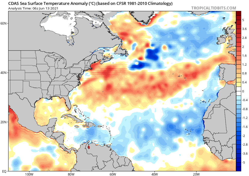
Taking a peek at sea surface temperature anomalies in the Atlantic, much of the area we usually watch for tropical development later in the season between the Lesser Antilles and Africa is cooler than normal. This is a promising sign for limiting the most intense hurricane activity later in the season, though there is still plenty of time for this pattern to change and it only takes one storm making use of “marginal” conditions to cause problems.
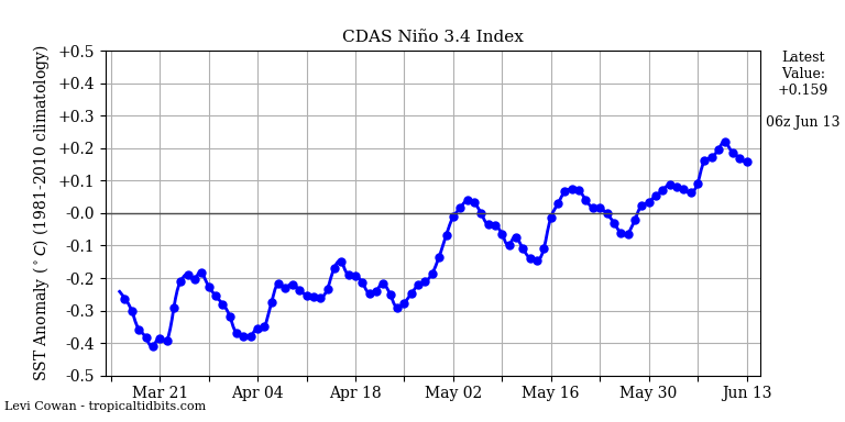
Over in the Pacific, ocean temperatures in the area we watch for to decide whether we’re experiencing “La Nina” or “El Nino” conditions have been warming this spring. Temps are still too cool for El Nino, but taking the edge off the La Nina we saw last year may also help temper Atlantic hurricane activity later in the season.
Overall, I think we’ll see another normal to above-normal hurricane season, though I leave much speculation past that to those with more long-range expertise. For now, we have our two systems to keep an eye on in the western Atlantic and we’ll see what the atmosphere hands us later.
Remember that now is a great time to review your hurricane plans and stock up on any extra supplies you might have used up last year. The more prep work you can put in when the sun is shining and the ocean calm, the less stressful it will be when a hurricane eventually wanders in your direction.
-Jack

Great report on the beginning of the hurricane season
LikeLiked by 1 person