Hello everyone!
Now that we have yet another active tropical cyclone and I’ve cleared the decks with my other projects a bit, it’s time to revisit this blog. I’ll be providing updates on Hurricane Delta here each day until the storm has made landfall along the northern Gulf Coast sometime Friday night or Saturday morning. As a reminder, you can also find my tropical weather discussions on twitter (@JackSillin), on the Hurricane Tracker App, and on Mark Sudduth’s HurricaneTrack Patreon page.
Delta formed in the Caribbean just 24 hours ago and is already a powerful Category Two hurricane with maximum winds of 100 mph. Satellite imagery shows very intense convective activity occurring in the storm’s small core west of Jamaica.
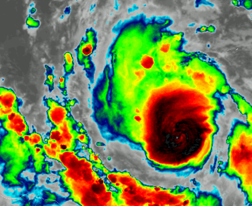
Though the storm’s eye is not yet readily apparent on satellite imagery, I suspect it will be soon. The reason we can’t see the eye on satellite imagery yet is that the thunderstorms in the eyewall are too intense relative to the strength of the circulation. Basically, the thunderstorms are pushing cirrus into the eye faster than the sinking motion in the eye can clear them out. As the circulation ramps up to match pace with the thunderstorms, sinking in the eye will become stronger and we’ll see an eye clear out. So at this point in a storm’s lifecycle, not being able to see the eye on satellite imagery is a sign of strengthening not weakening.
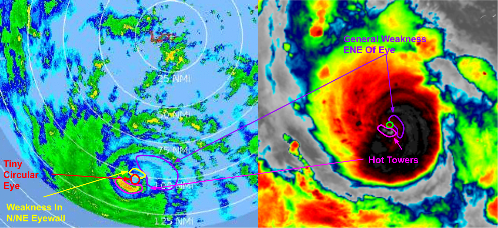
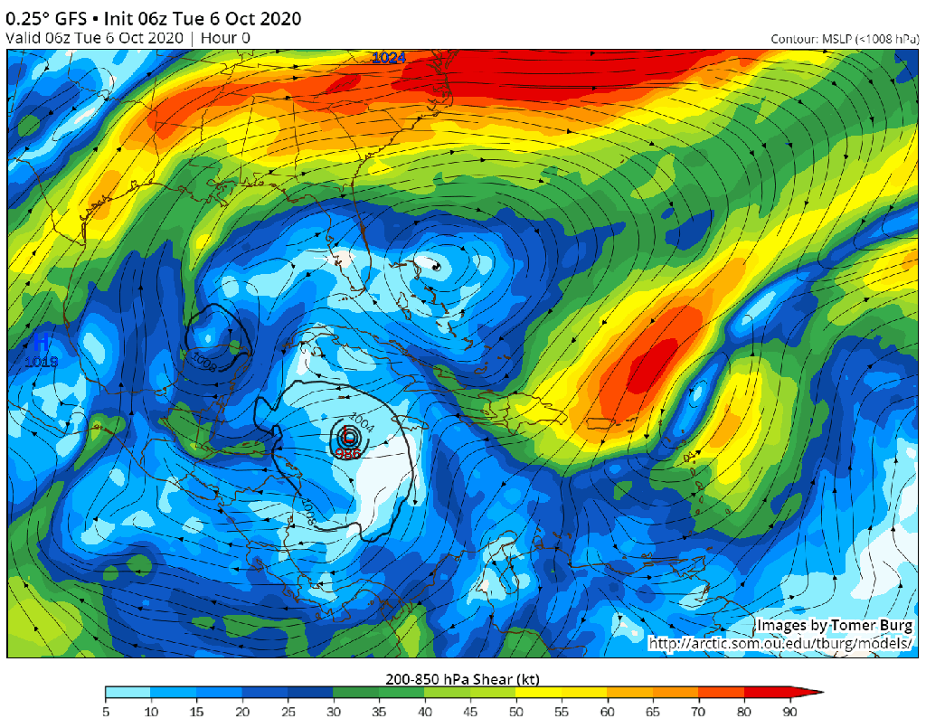
Taking a quick look at the storm’s inner core as observed by radar imagery from the Cayman Islands as well as GOES-East satellite imagery, we can see that while the storm has a small and circular eye, there’s a bit of a “hole” in the core on the northeastern side. This is likely due to some very subtle northeasterly shear imparted on the storm by the upper-level high off to its north. The convection we’re seeing in Delta’s eyewall is so intense that I don’t think this shear will slow the storm down much, but perhaps this is why we don’t have an even-stronger hurricane yet.
By this afternoon/evening, that shear should weaken and the environment will be picture-perfect for continued rapid intensification.
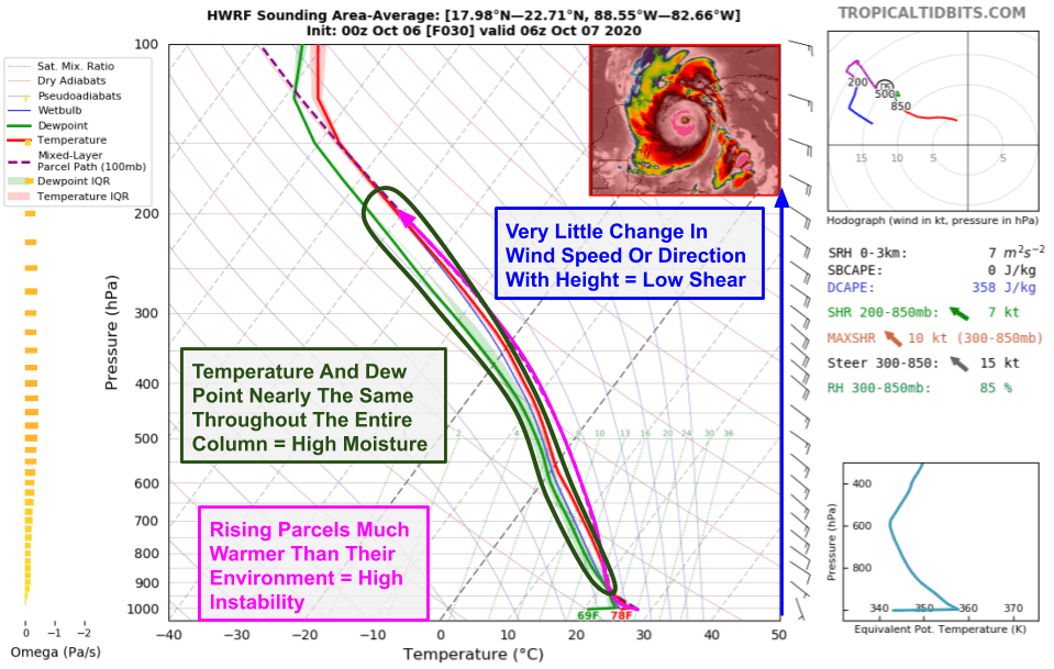
Area-averaged soundings from the HWRF show every environmental box for tropical cyclone intensification checked this evening. Winds will be uniformly around 15kts out of the east-southeast so shear will be very low. The spread between the temperature and the dew point is very low throughout the atmospheric column which means that dry air won’t be of any concern. Strong heat and moisture fluxes from the incredibly warm ocean mean that rising air parcels will be considerably warmer than their surroundings and thus will rise rapidly due to buoyancy. Outside of inner-core fluctuations that are hard to anticipate, there’s nothing stopping Delta from continued RI today.
This is most immediately concerning for Cancun and adjacent parts of the northeastern Yucatan Peninsula, where Delta will arrive early tomorrow morning.
Current forecasts from our suite of high-resolution hurricane models indicate that Delta will make landfall near Cancun as a powerful Category Four hurricane. This is what the official NHC forecast is calling for too. Impacts in this area will include destructive winds of 120-140 mph, storm surge of several feet, and torrential rains capable of causing flash flooding and mudslides. Residents in these areas need to be preparing now for life-threatening conditions beginning later tonight.
While some weakening is expected as Delta interacts with land, the storm’s brisk motion means that it won’t spend much time away from water. By tomorrow afternoon, the storm will be back out over the Gulf of Mexico ready for another round of intensification. While waters won’t be quite as hot as in the Caribbean, the environment over the southern Gulf tomorrow night looks pretty darn similar to that which we’re seeing in the Caribbean today.
On Thursday, the storm will begin turning towards the north in response to southwesterly flow developing aloft ahead of an upper-level trough over Texas.

While the confidence in some type of northerly->northeasterly curve is quite high, we don’t yet know exactly where that turn will happen. If it occurs sooner and/or is a bit sharper, the storm’s track could shift a little bit east. If the turn occurs a bit later and/or isn’t quite as dramatic, the storm’s track could shift a bit west. That’s one reason why even though Louisiana has the highest chance of seeing a landfall from Delta, folks anywhere from the Upper Texas coastline to the western Florida Panhandle need to have a very close eye on this storm. The other reason of course is that hurricanes are not point features, and dangerous impacts will extend well away from the center.
Delta will approach the Gulf Coast Friday evening before making landfall sometime Friday night or Saturday morning. During the last 6-12 hours before landfall, the storm will face a few hurdles that are likely to knock a bit off its maximum intensity (whatever that ends up being).
The first hurdle will come in the form of some increased wind shear due to that upper-level trough over Texas. While winds turn southwesterly aloft, they will remain southeasterly closer to the ground. That change in wind direction with height is wind shear, and will put some stress on the hurricane’s vortex. If Delta were a small and newly-formed system (like Marco earlier this year), I’d say that the odds of this shear weakening the storm dramatically before landfall were relatively good. However, when the shear kicks in over Delta, it will be a powerful Category Four hurricane that already has a well-established vortex. Persistent shear can weaken strong hurricanes like this, but it takes some time. These storms don’t just go poof like little Marco did. They take a while to “spin down”. Unfortunately, Delta will be moving quickly at this point in its lifecycle. Even 6-12 hours of wind shear won’t be enough to avoid a powerful hurricane landfall with significant impacts.
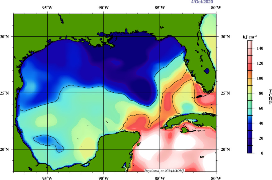
The second speedbump for Delta will be the decrease in ocean heat (hurricane fuel) over the northern Gulf. This is due to the cooling effect of several cold fronts that have swept through the region in the past few weeks. While the storm is currently enjoying off-the-charts heat over the NW Caribbean, cooler water lurks over the Gulf. There’s enough heat in the southern Gulf (south of 25N) to support a major hurricane, but Delta won’t be able to spend much time north of that without running low on gas.
That said, the forward motion caveat applies here too. Much like a car running out of gas going down the highway, hurricanes don’t stop immediately after moving into cooler waters. It takes time for all that momentum to dissipate. Delta will only have 6-12 hours over this cooler water before making landfall. While that is welcome news in a season where several hurricanes have rapidly intensified right up until landfall, it will not be enough of an impediment to prevent major impacts.

The third speedbump will be dry continental air moving into the storm’s southwestern flank. This dry air will attempt to wrap into and weaken Delta’s core, but I’m skeptical it will have enough time to make a substantial difference. That said, given the southwesterly shear, the dry air may have an easier path into Delta than it did into Laura earlier this year in the same part of the Gulf.
So all that to say that Delta will likely be slowly coming off its peak intensity as it moves towards the Louisiana coastline. Its maximum winds at landfall are likely to be somewhat lower than its maximum winds over the Caribbean or southern Gulf of Mexico. But that does not mean this won’t be an extremely dangerous hurricane for parts of the Louisiana coastline (and perhaps parts of far eastern TX and/or MS/AL/W FL). It’s crucial to remember that the process of hurricanes weakening involves all the momentum they’ve built up slowly becoming less concentrated. So while winds near the center might be decreasing, the overall wind field usually expands to satisfy the conservation of angular momentum. This process is helped along by eyewall replacement cycles, of which Delta is likely to complete at least one.
Residents in Louisiana need to have their hurricane plans ready to go for when watches and warnings are issued in the next couple days.

I’ll leave you with a look at the NHC’s official forecast for Delta which neatly summarizes many of the ideas I’ve discussed here. I cannot stress enough how little you should focus on the icon over Louisiana at 2 AM Saturday being an “H” for Hurricane instead of “M” for Major Hurricane. I can assure you that you will not be able to notice the difference between a 110 mph Category Two and a 115 mph Category Three, and this storm will be extremely dangerous regardless of its maximum sustained winds at landfall.
I’ll have more updates throughout the day on twitter (@JackSillin).
-Jack
