Hello everyone,
Hurricane Delta is moving through the Gulf of Mexico this morning and intensifying slowly as it does so.

The storm is still struggling to become a well-organized hurricane this morning. Wind shear is lighter now than it was yesterday, so it’s not immediately clear to me why we haven’t seen convection take off on the storm’s eastern/northeastern side. Perhaps that will change later today. Either way, the big takeaway from current observational data is that Delta’s footprint has expanded significantly over the past couple days. While this makes extremely rapid intensification harder to pull off, it means that a wider swath of the coastline will experience strong winds and storm surge will be considerably larger.

The modest intensification and significant expansion of Delta’s wind field is best visualized with hourly forecast model data. I made this animation yesterday afternoon but the forecast hasn’t changed meaningfully in the intervening hours.
The same thought applies to the animation below which uses data from yesterday’s model guidance but remains relevant because forecasts haven’t changed much in the time since.
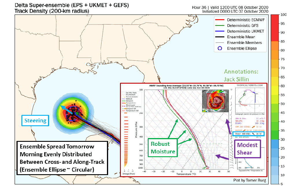
As Delta turns north today, the biggest question will be how quickly it’s moving. Ensemble members are in excellent agreement about the general track of the storm. Landfall will occur somewhere in SW Louisiana (exact town dependent on wobbles etc.) it’s just a matter of figuring out when. The current NHC forecast calls for landfall sometime late tomorrow afternoon. The range of possible outcomes in my mind is somewhere between midday tomorrow and early Saturday morning. Either way, today’s the last full day of relatively quiet weather during which you can safely prepare for the storm.
While I don’t think this matters all that much in the end, a slower Delta might slide a smidge farther west due to the weakening trough over Texas. But this would probably be on the order of 15-25 miles rather than some big lurch into Texas. If you’re in Houston, I think you can rest easy knowing that the worst of Delta is headed well to your east (though minor impacts are possible).
Now let’s take a look at Delta’s forecast from an impacts-based perspective.
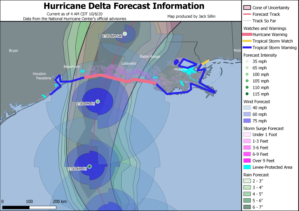
This map is an overview of the National Hurricane Center’s forecast for Delta’s track, intensity, and rain/wind/surge impacts. The areas most seriously impacted by the storm will be along the coast between Lake Charles and Lafayette Louisiana, as well as points inland. Unfortunately, many of these areas are still recovering from the devastation of Hurricane Laura just six weeks ago.
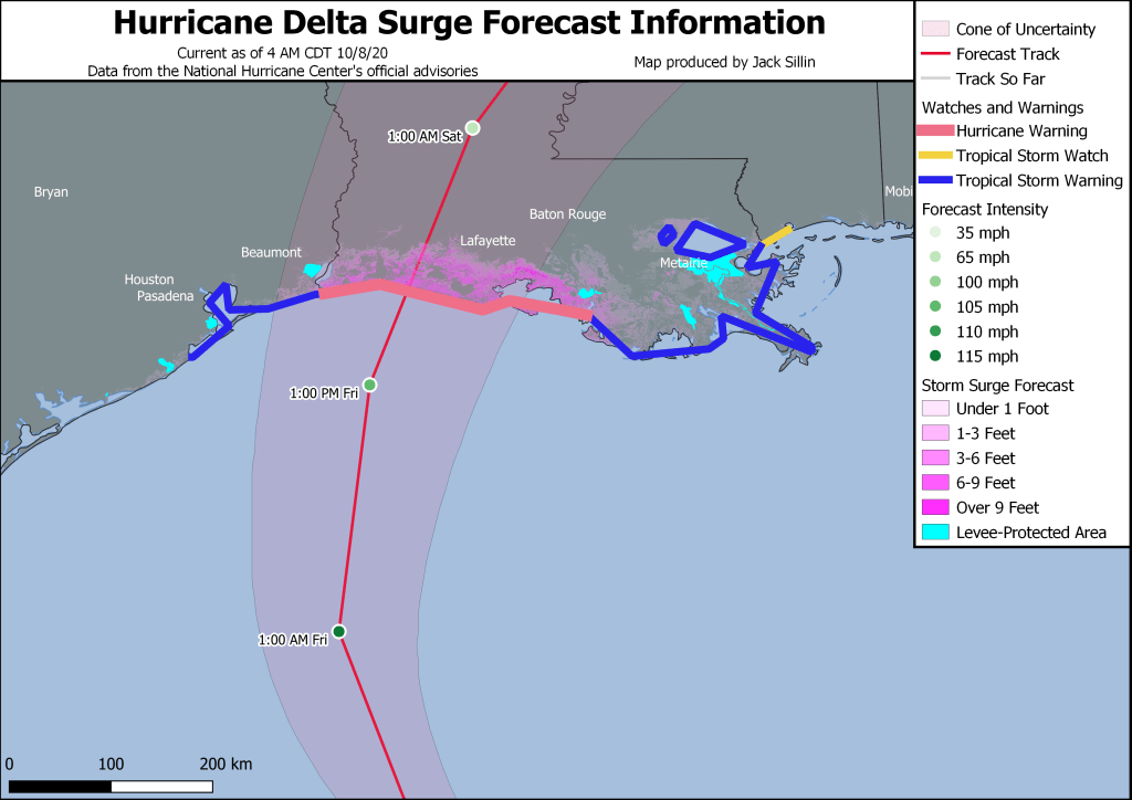
As per usual, storm surge is the biggest concern as Delta moves ashore. This map provides a clearer view of the NHC’s inundation forecast which calls for parts of coastal Louisiana southeast of Lafayette to be under 9+ feet of water sometime Friday evening. If you’re in this area, please heed the instructions of local officials and evacuate if you are told to do so. Surge will cause some issues as far west as Beaumont/Port Arthur and as far east as coastal Mississippi.
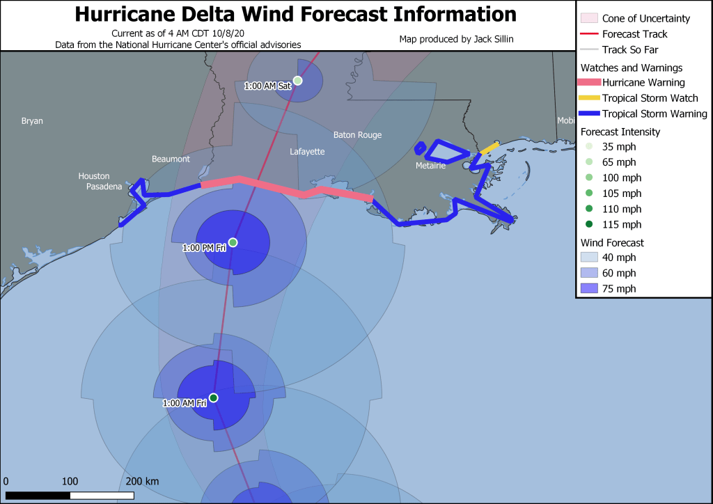
High winds will also be of concern near where Delta makes landfall. Our current best guess at Delta’s maximum sustained winds during landfall is somewhere around 100-110 mph. Perhaps if the storm can intensify a bit more today, those numbers might be a little higher. But I’m less concerned by the maximum wind number than I am about the size of the wind field and how fast the storm will be moving. The larger wind field means that more people will experience tropical storm-force and hurricane-force winds even if there aren’t any major-hurricane-force winds right near the core. The storm’s fast forward motion means that strong winds will be able to move farther inland than we’d otherwise expect. Even if you’re 100-200 miles north/northeast of the point of landfall, you should be prepared for strong winds and power outages.
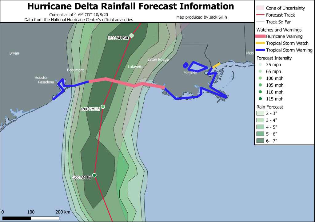
Delta’s fast movement isn’t all bad news. Because the storm won’t be lingering in any given location for very long, the rain threat should be manageable. Our best rainfall forecasts currently indicate the potential for 4-8″ of rain along and just west of Delta’s track. That’ll undoubtedly cause flash flooding issues in spots but we shouldn’t see much if any major/widespread flooding like we did with Sally or other slow-moving storms.
Delta will quickly dissipate over the Tennessee Valley this weekend.
-Jack
