Hello everyone!
The main focus of my coverage in recent days has been on Hurricane Sally which poses a serious threat to the Gulf Coast, but there are six other tropical entities in the Atlantic that bear watching today. Thankfully, none of them pose the level of risk to land that Sally does. This post will briefly examine each of those other systems. Another post will focus on taking an updated look at Sally.

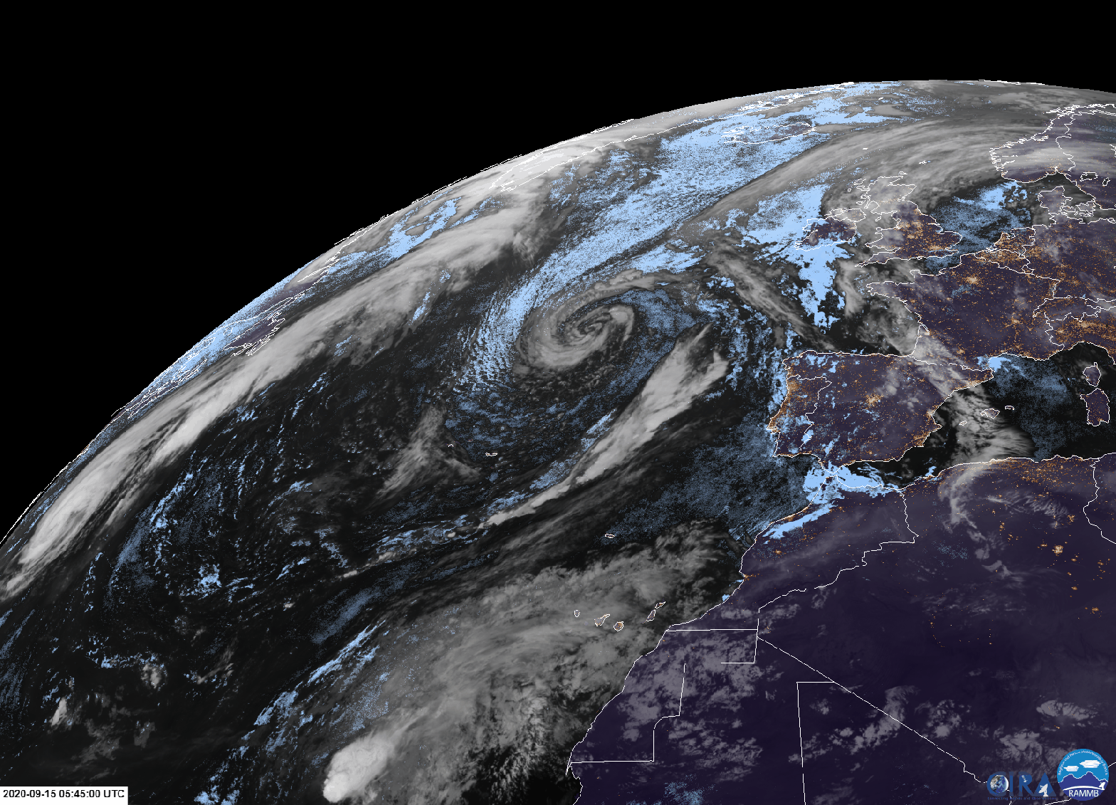
Satellite imagery of the Northwestern Hemisphere clearly highlights each of our disturbances to watch today. Our four named storms in various states of organization plus three disturbances that we’ll have to watch for potential development in the next few days.
Off the East Coast, Paulette continues to move northeast away from any and all landmasses.

The storm was expected to intensify during this part of its journey due to lower shear and favorable interaction with a mid-latitude jet streak over far eastern Canada. However, the storm’s inner core structure is a bit sloppy (a la Sally) and it hasn’t really been able to pull itself together. Regardless, the storm remains quite dangerous for mariners in this part of the North Atlantic.
Paulette’s remaining threat to land will come in the form of large swells along the East Coast today.

This buoy about 50 miles southeast of Nantucket shows swell heights around 8-10 feet this morning with a period (not shown) of 14-15 seconds. That means these waves are packing tons of energy and will be quite dangerous for those that get close to them as they break. If you’re an experienced surfer, have fun riding these waves. For the rest of us, keep a safe distance.
Moving farther out into the Atlantic, we’ll find Tropical Storm Teddy several hundred miles east of Barbados.

Teddy looks really good on satellite imagery at sunrise this morning, it just needs to focus its intense thunderstorm activity near its center. Once that happens, it should have no trouble intensifying into a major hurricane. The storm is currently in a moist, low-shear atmospheric environment above very warm ocean waters. Its intensity ceiling is very high, and we may see it make a run at Category Four status by this weekend.

Teddy is forecast to move basically due northwest for the next five days, during which time it will not impact land. There’s some uncertainty once we get to the day 4-5 timeframe when some guidance suggests a potential shift in the storm’s track off towards the west-northwest. As of right now, I’m not inclined to see Teddy as a major threat to land but it does bear watching. We’ll revisit this steering pattern after we’re done with Sally.
Northeast of Teddy is tropical storm Vicky.

Sunrise over Vicky reveals a cyclone being acutely impacted by strong southwesterly wind shear. Notice how the storm’s low-level swirl is displaced significantly from its deep thunderstorm activity. This shear is being delivered by a strong upper-level low to the northwest of Vicky and will bring about the system’s rapid demise later today.
Rene became a remnant low yesterday, so this concludes our tour of the active tropical cyclones in the Atlantic not named Sally.
Closer to the African coast we’ll find our next tropical wave to watch for development.

This wave is producing relatively deep convection this morning and it’s starting to coalesce around what might be an incipient center of circulation. The environment surrounding the system is fairly supportive of intensification, and I’d expect to see yet another tropical depression or storm develop from this system in the coming days.

Most model guidance isn’t too bullish on this system’s future intensity, though the GFS parallel model (new version in beta testing) takes it up to hurricane strength briefly while recurving into the open ocean. No impacts are expected from this system. If named, this will be called Wilfred and will use up the last name on the list for the Atlantic this season. Future storms will then be referred to by the various letters of the Greek Alphabet.
One of those future storms may very well be this feature west-northwest of Portugal.

Satellite imagery shows the system’s frontal features becoming detached from its center where convection is beginning to build. If convection persists for long enough, it will release enough latent heat into the storm’s core for it to be considered a tropical or subtropical storm.

This graphic shows the cyclone’s expected evolution from “asymmetric warm core” or subtropical (which is where it is right now) towards “symmetric warm core” or tropical by later today/tomorrow. Even if the storm does become tropical, it will weaken substantially before impacting Portugal in four or five days. But perhaps the storm could snatch the name “Wilfred”, leaving the wave in the eastern Atlantic to become “Alpha”.
Way back in the southwestern Gulf of Mexico, we’re still dutifully watching this system which is producing some shower and thunderstorm activity east of northeastern Mexico.

The system hasn’t yet been able to focus its thunderstorm activity around a single center, but if this current burst is able to hold through the day today, it could. NHC penciled in a recon flight for this afternoon, but unless it looks like a low-level center might be present, they’ll probably cancel it.
Either way, it doesn’t pose much threat to land in the short-term. We’ll revisit its future in more detail after Sally.
Finally, it appears as though the Atlantic Basin’s tropical cyclone activity is mildly contagious.

The Mediterranean Sea may join in on the action this week as a low near Libya moves northeast towards Greece. The Mediterranean gets systems like this every once in a while, so this development (if it were to occur) would be unusual but not unprecedented.
More coverage of these systems in the coming days, especially after we’re done with Sally.
-Jack
