Hello everyone!
While there are plenty (seven!) of systems to watch across the tropical Atlantic this morning, our focus remains on Tropical Storm Sally which is expected to intensify into a hurricane before impacting the New Orleans area and adjacent parts of the northern Gulf Coast beginning tomorrow and continuing through Wednesday.
In recent days, I’ve spent considerable time on the blog explaining the meteorological processes working both for and against intensification, as well as pushing the storm in different directions. If you want to dig into the nerdy details of this system’s forecast, feel free to read over last night’s post if you haven’t already. Pretty much all the info there is still current even if the satellite loops are a little stale. This update will focus much more on the system’s expected impacts as it moves onshore somewhere in southeastern Louisiana and/or southern Mississippi.
As a quick reminder, you can sign up via the box on the left sidebar to receive my updates via email the moment they are posted if that’s something you’re interested in.
Overview
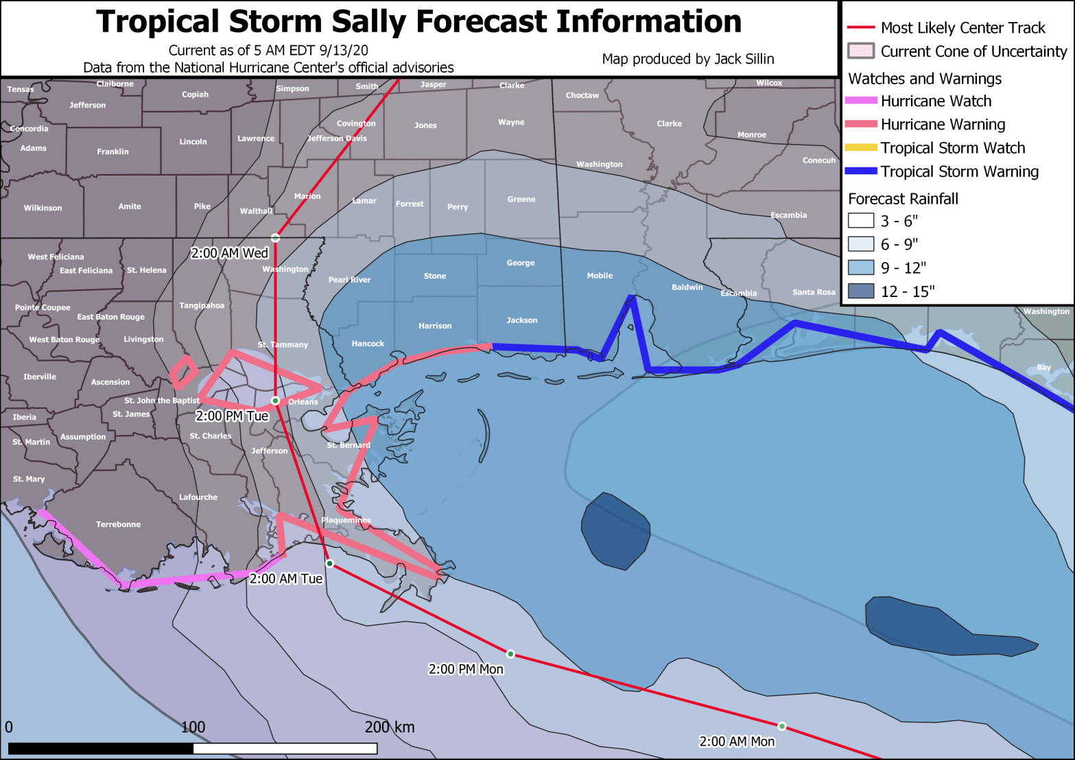
Our primary guide for this morning’s updates will be the info NHC sent out in their 5 AM EDT advisory on the storm.

This map shows the storm’s expected track, intensity, and rain/wind/surge impacts as well as the watches and warnings in effect as of 5 AM EDT. Click the map for a larger version that’s a bit easier to read. The key idea to take away from this graphic is that serious impacts, especially heavy rain, will extend relatively far from the center of Sally, especially to the east. So folks in the Florida Panhandle and southern Alabama shouldn’t let their guard down despite not being near the center of the cone (or in the case of most of FL, outside the cone entirely).
Surge

This map is zoomed in near where Sally is expected to make landfall in southeastern Louisiana and shows the storm’s forecast track, intensity, and storm surge. Note that areas outside the New Orleans levee system could see over nine feet of storm surge inundation as Sally’s circulation pushes water from the Gulf of Mexico west and northwest towards Lake Pontchartrain. As someone unfamiliar with the New Orleans levee system, I do not know which levees might or might not be in danger of failure from a surge of this magnitude. Local officials in this area do have that information, and if they tell you to leave, please make every effort to do so. If you don’t have the resources to evacuate, please get in contact with your local officials who will likely be able to assist you with transportation, accommodations, etc.
Surge will also be an issue well east (and somewhat west) of where Sally moves onshore. Southern Mississippi and parts of southern Alabama could see over six feet of surge if Sally ends up making landfall in SE Louisiana as a hurricane (which is the current NHC forecast). Areas as far east as the Big Bend region of Florida will see surge from Sally in the range of 1-3 feet. This will cause problems in the usual low-lying spots prone to flooding from even “minor” events.
Rain

Heavy rainfall will pose an extremely serious threat to parts of SE LA, southern MS, southern AL, and western FL. Light westerly wind shear has pushed most of Sally’s thunderstorm activity to the east of the center which means that heavy rain will extend well east of wherever the center makes landfall. As the map above highlights, 9-12″ of rain is likely as far east as Panama City Florida. This amount of rain, with locally higher amounts (to 20″ or more) will cause serious and widespread flooding. If your area is vulnerable to flooding from heavy rain, consult with information from your local officials and be prepared to evacuate if told to do so.
Heavy rain will also be an issue near the center landfall location in SE Louisiana, but totals will drop off fairly quickly as you head west.
Wind

I’ve discussed wind last here because even for those areas expecting hurricane-force winds, what’s happening with the air will be the least of your worries. What’s happening with the water (both rain and surge) is a much bigger threat to your life. That said, strong winds will cause problems along and especially east of Sally’s center track. As of 5 AM EDT, NHC forecasts call for landfall as a 100 mph category two storm. That means that most places near the center of the storm will see sustained winds of 75-85 mph. Remember that the “maximum sustained wind” forecast number really only applies to areas over open water and perhaps some immediately adjacent beachfront locations. It’s also important to keep in mind that you don’t need 100 mph winds to cause serious issues. Even winds of “only” 50 mph will knock down trees and power lines. Winds of 50-75 mph will cause increasingly widespread tree/power line issues and may start to cause some minor structural damage. Winds above 75 mph begin to pose a more serious threat to siding/roofs.
Uncertainty
All the above information is based on the best available forecast info we have this morning. But that’s not to say we’re 100% confident about how strong Sally will be at landfall or where exactly it will move onshore.
Recall from yesterday’s post that the environment Sally will occupy starting tonight is extremely favorable for rapid intensification if the storm can wrap convection around its inner core.

With that in mind, there remains the potential for Sally to strengthen more than currently forecast. I’ve advised my friends in the New Orleans area to prepare as if Sally were making landfall as a Major Hurricane (Category Three) because that outcome is well within the range of reasonable possibilities given the environment. If the northwesterly shear is just light enough to keep the low- and mid-level circulations displaced, and Sally ends up coming onshore as a “weaker” (but still quite dangerous!) hurricane, we can all be thankful it wasn’t worse. Prepare for the reasonable worst-case outcome (Category Three landfall) and hope for the reasonable best-case outcome (low-end Category One or high-end Tropical Storm landfall).
It’s also worth noting again that the category system only takes into account a storm’s maximum sustained wind speed which, as mentioned above, is not representative of the winds most folks (even near the center) will experience, nor does it convey any information about the significantly more dangerous rain/surge threats.
Looks Will Be Deceiving
Even in the scenario where Sally moves onshore as a Category Three hurricane (depicted by the 00z HWRF model as an example), it is not likely to achieve its final form until it’s right at the coastline.

This image is from that HWRF model run that represents the “reasonable worst-case outcome” for Sally. The forecast map is valid tonight at 8 PM EDT. Note that the system is still a mid-grade tropical storm with the low-level center significantly displaced from the strongest convection. Even if we were to see little organization of the system today, it still has the potential to rapidly intensify tomorrow. You should not wait for the storm to take on the appearance of a “classic” hurricane with a well-defined eye before you take it seriously. By then, it will be too late to do anything but hunker down and hope for the best.

This animation shows the HWRF’s prediction of what satellite imagery might look like between now and the storm’s landfall. Note that even in this bullish model depiction of Sally’s intensity, the eye only shows up clearly once the system is directly over New Orleans!
After making landfall, Sally will move slowly north until it dissipates over Mississippi. The slow movement is welcome news from a wind perspective (widespread wind damage will not continue well inland like it did with Laura) but is very bad news from a surge/rainfall perspective. Heavy rain and strong onshore winds will linger into Wednesday even as the storm weakens just inland.
I’ll have updates throughout the day on twitter and will most likely be back here on the blog this evening with an updated look at expected impacts.
-Jack
