Hello everyone!
Since Hurricane Elsa back in early July, the tropics, and this blog, have remained rather quiet. This can be attributed to the passage of what meteorologists call the “suppressed phase of the Madden-Julian Oscillation (MJO).” The MJO can be thought of like a wave that travels around the earth near the Equator. All waves have peaks and troughs, and one way to think of those features in the MJO is in terms of favorability for tropical cyclone activity.
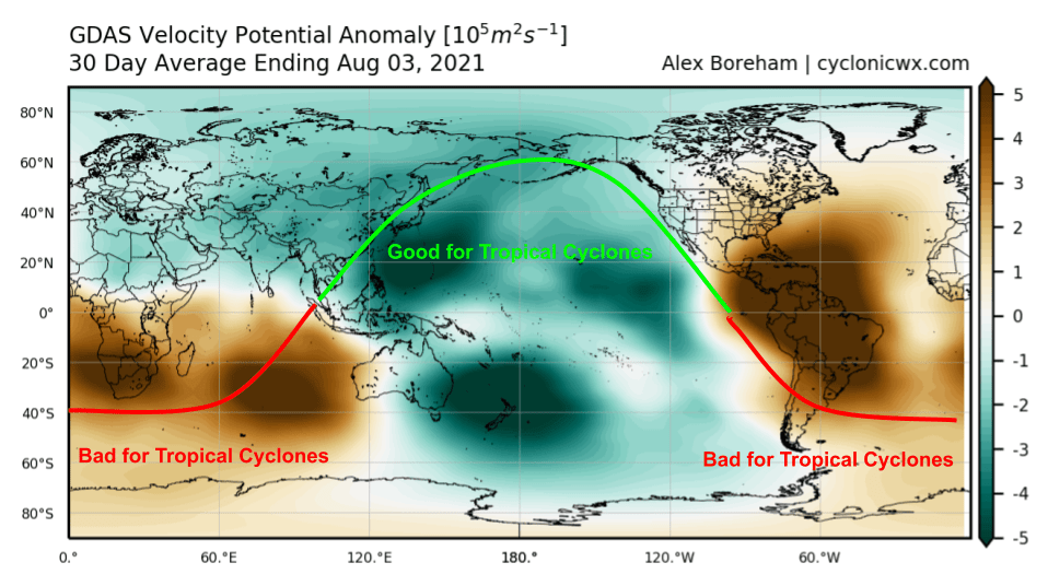
While the field shown in this plot (velocity potential anomaly) is a bit esoteric, the general idea is that it can point us towards parts of the world more and less favorable for tropical cyclones. For the past month or so (this map shows the average conditions over the last 30 days), conditions have been kind to tropical cyclones in the Pacific (we had several systems both in the eastern and western parts of the basin during July) while the Atlantic has been “closed for business”.
For meteorologists or seasoned weather nerds, I should note that this oversimplifies the MJO and its signal in VPA fields a bit. FSU Ph.D. Candidate Jake Carstens has a pretty good explanation for the interested non-scientist if you’re curious to read more. If you’re really hungry to explore the mechanisms behind the MJO and how exactly it modifies the large-scale environment towards or away from conditions favorable for tropical cyclones, you can peruse this twitter thread where I learned from some of the experts in this area.
Unfortunately, our luck with the MJO suppressing Atlantic TC activity appears to be running out.
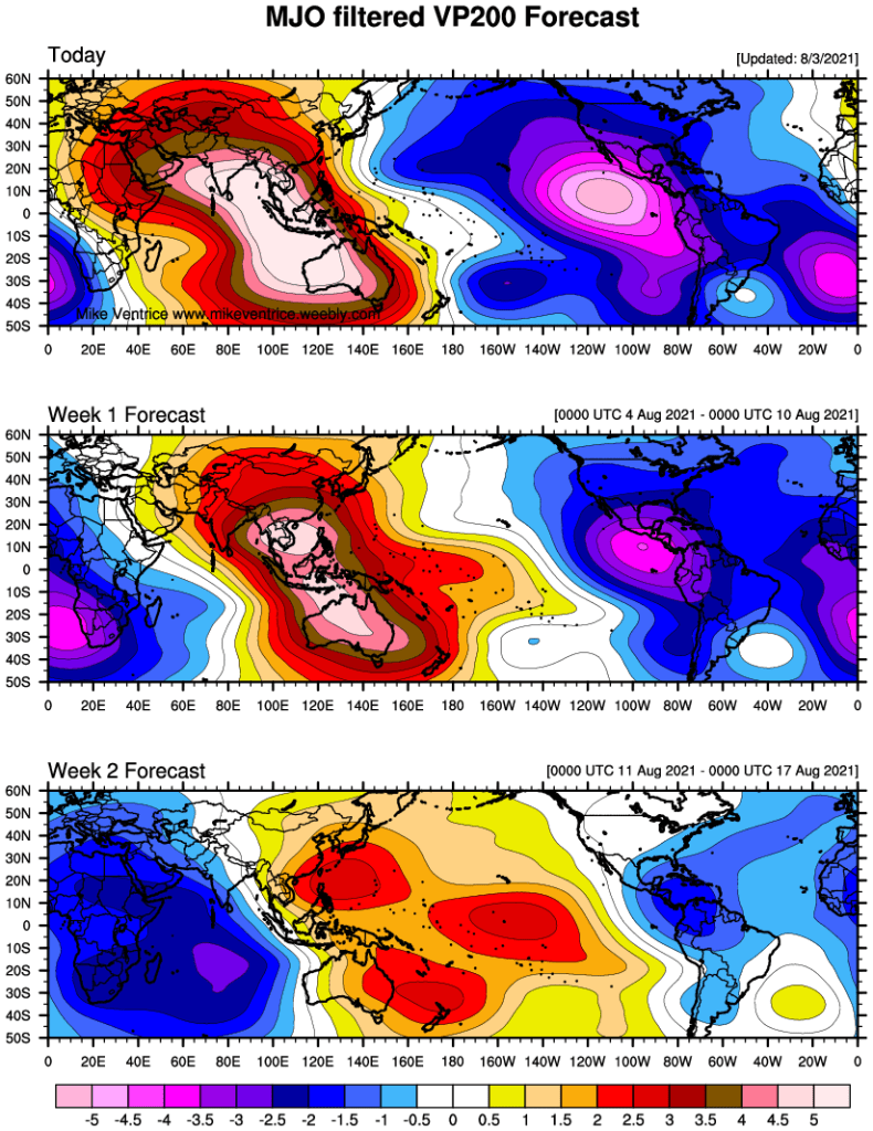
These plots show forecasts for the MJO during the next couple weeks. Note that the week two forecast is the exact opposite of the pattern we’ve seen for the past month or so. The Pacific should quiet down under +VP anomalies signifying upper-level convergence while the Atlantic benefits from some -VP divergence and, perhaps more importantly, reduced shear from easterly outflow away from the VP minimum over Africa.
So starting in a week or two, we should have a bit more to discuss in the tropics. The first signs of life are already beginning to show up over the eastern Atlantic where the NHC has outlined two areas for potential tropical cyclone development in the next five days.
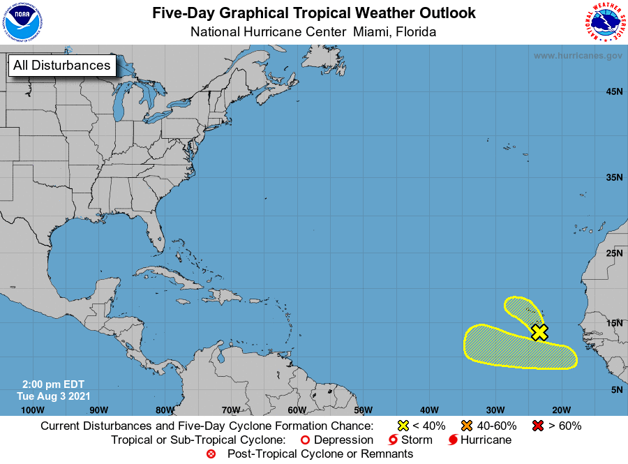
Both these systems are embedded within a broad “monsoon trough” or region of convergence between easterly trade winds and westerly winds near the equator. This generally means they will be slow to organize, and slow to move west (compared to systems originating from tropical waves moving off Africa).
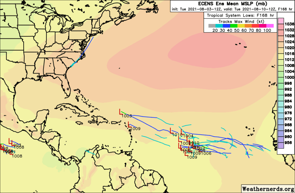
The second system (not yet designated with an “X” on the NHC map) has a slightly better shot of development in my opinion as the one currently south of the Cabo Verde Islands gets pushed north into colder water. There is some ensemble support for the second system, but even if it were to develop, it would only be about half way across the Atlantic in a week’s time.
So there’s plenty of time to gradually train our eyes back towards the tropics in the next couple of weeks. No land areas will face the threat of tropical cyclone impacts for at least another week or two, which means that now is a great time to check in on your hurricane plans and top up on any supplies you may have gone through last year or during the pandemic. Stocking up on non-perishable items and planning a bit now before lines at the store are long and impacts imminent will be a huge help whenever a storm heads your way, be it in a few weeks, a few months, or a few years.
I’ll keep this blog updated as new information about the tropics comes up. Hopefully we all have a couple more weeks of rest ahead of us before the season really picks up.
-Jack
