Hello everyone!
It’s an extremely busy day in the tropics as we have six systems to watch from the Gulf of Mexico to the shores of western Africa.

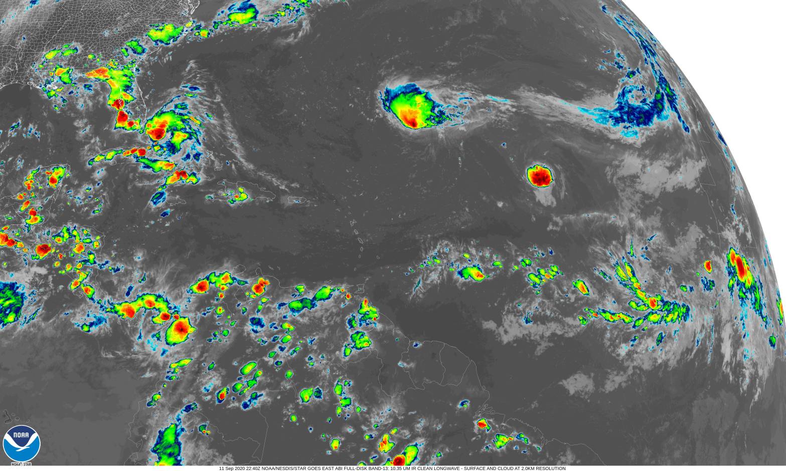
Each of these systems can be seen on this satellite image of the Atlantic a little earlier this afternoon. In order from west to east: the trough over the NW Gulf with a 30% chance of development within five days, TD-19, Paulette, Rene, 95L, and the next wave just emerging off Africa.
This post will start with a quick look at Paulette before taking a deep dive into TD-19’s forecast. None of the other systems will be mentioned due to their relatively low threat to land (zero for Rene, unclear long-term threat for 95L, minor longer term threat from the GOM trough, and potential for showers in Cabo Verde from the next wave) and the presence of more pressing systems.
Before we really dive into this evening’s update, a couple notes. If images are too small for you to get a good look at, you can click them for a larger version. If you’d like to get these updates in your inbox, you can sign up with the box on the left sidebar near the top of the page. If you’d like to see more tropical weather updates from me while supporting a super cool hurricane research project, head on over to Mark Sudduth’s Patreon page. If you prefer to support me directly, I also have a personal Patreon page. It’s like Mark’s except without all the cool extra posts and the money goes to buying my textbooks instead of collecting data from inside hurricanes.
Paulette

The strongest system in the Atlantic this evening is Paulette with winds of 65 mph. The storm is expected to become a hurricane tonight or tomorrow as it continues tracking northwest towards Bermuda. Significant impacts from Paulette are likely in Bermuda as the storm passes nearby on Monday morning. Just how close to the island the storm gets will determine the extent to which rain/wind/surge will cause problems there. If you’re looking for more of my thoughts on Paulette and Bermuda, I took a bit of a closer look in my post this afternoon for Mark Sudduth’s page.
For those of us along the East Coast, Paulette is nothing to worry about outside of concerns relating to large swells and rip currents. If you’re an experienced surfer, by all means enjoy the powerful swells. For the rest of us, stay out of exposed ocean waters where intense rip currents pose a serious threat to your life.
TD-19
TD-19 was just designated east of Florida from the system we’ve been calling 96L up until today.

Satellite imagery shows an increasingly healthy system this evening with fairly expansive upper-level outflow (still needs to work on the northwestern quadrant and intense thunderstorm activity bubbling up near the system’s center (especially towards the end of the loop). Those persistent bursts of thunderstorm activity over the center will be key for the system’s development over the next few days. If thunderstorm activity continues tonight the way it has been this afternoon, I honestly wouldn’t be shocked to see TD 19 upgraded to TS Sally by the 8 PM or 11 PM EDT updates.

TD-19 is close enough to the Miami radar that we can actually get some pretty good information about the system’s structure by peering under the cirrus canopy and into the lower-level parts of the storm. The mid-level circulation is located in the cluster of intense thunderstorms just off Andros Island while the lower-level center (lowest surface pressures inferred by observations in Florida and buoys/ships offshore) is a bit northwest over the Florida Straits. This infers the presence of some light northwesterly wind shear which is preventing the system from becoming fully aligned.
That wind shear is being caused by a weak upper-level low drifting southwest across central Florida. As that low slides farther southwest, continues weakens, and the deep convection associated with TD 19 begins to produce a response in the lower-level mass fields (i.e. enough air rises in the big thunderstorms that more has to move horizontally towards the storm’s center to take its place), I’d expect to see this misalignment resolved. It also helps that the low-level center is somewhat poorly defined and doesn’t have much angular momentum built up yet so a center relocation underneath that deep convection is pretty easy for a storm like this to pull off.

Microwave imagery from around 5 PM shows a system well-positioned for intensification with a curved band of convection developing around the mid-level center. Note that the convection hasn’t yet wrapped around to the northwest of the mid-level center, due in part to the wind shear mentioned above. If that band can close off, TD-19 could make a run towards mid-grade TS status before landfall tonight. That’s far from a guarantee given the NW shear, and it would only impact a few towns right along the beach where the very small core comes ashore, but it’s something to be mindful of if you live in the Miami area. Don’t be shocked if your power flicks off for a few hours tonight if TD-19 happens to tighten up a bit before landfall and you happen to end up in the small portion of the circulation that contains 40-50 mph winds.
After moving onshore tonight, TD-19 will quickly move across the southern part of the peninsula before emerging offshore tomorrow afternoon. The state of the system at this point is a bit of an unknown because we don’t know how robust the circulation will be when it moves onshore tonight and we don’t know to what extent the circulation will fall apart over land. We also don’t know how long the storm will spend over land because its exact track is a bit uncertain owing to near-term wobbles induced by the strong convection discussed earlier.

Either way, by tomorrow afternoon TD 19 will be offshore between Naples and Key West. At this point, it will begin to strengthen in an environment favorable for tropical cyclone development.
For tropical cyclones to develop and intensify, three main ingredients are needed: warm water, low vertical wind shear, and relatively high mid-level moisture. Sea surface temperatures are over 30C in the Gulf of Mexico at the moment (need ~26C for tropical storms, ~28C for hurricanes) so there’s nothing holding the storm back on that front. What about shear and dry air?

This area-averaged sounding over TD-19 tomorrow evening shows no dry air or wind shear in sight as the system sits within a very moist environment characterized by nearly uniform east-southeasterly winds between 5 and 10 kts. This basically means that there’s very little if anything holding TD-19 back as it moves into the eastern Gulf on Sunday.

As a result, it’s not surprising to see the models that are designed to offer more accurate intensity forecasts for tropical cyclones bring TD-19 quickly up to a strong TS by Monday. The animation above shows the HWRF which shows TD-19 coming very close to landfall in AL as a category one hurricane by Monday night. Much like other storms this season (Hanna, Isaias, arguably Laura), the biggest cap on TD-19’s intensity will be its limited time over water.
With that in mind, generally speaking if TD-19 wobbles south tonight/tomorrow or winds up tracking farther SW on Sunday, it will have more time over water and will thus have more time to intensify.

Now that we understand the rough contours of TD-19’s forecast including what factors will influence its intensity, its a good time to present the NHC’s forecast for not just the storm’s track (cone of uncertainty + “most likely” centerline forecast) but also its size. Note that the system starts out relatively small but quickly expands as it approaches the northern Gulf Coast. This means that, as per usual with tropical cyclones, impacts will extend well beyond where the actual center makes landfall. So even though we still don’t know where exactly the center will move onshore (SE LA or FL Panhandle or anywhere in between), folks along this part of the Gulf Coast should start getting their hurricane plan ready tonight/tomorrow in anticipation of needing to take actions Sunday or Monday.
As the storm approaches the northern Gulf Coast on Monday, it will slow down and turn towards the west in response to a bit of a collapse in steering currents.

This area-averaged sounding from the GFS valid Monday morning shows very little environmental steering flow over the system, aside from some very weak (~5kt) east-southeasterlies in the lower levels of the atmosphere. What impacts might this have on TD-19 and the weather for W FL/S AL/S MS/SE LA?
The first noteworthy impact will be an increase in the heavy rain threat. Slow-moving tropical cyclones, as this looks to be, are notorious for producing very heavy rainfall. Even if the storm doesn’t become a hurricane, it will produce very heavy rain that will cause flooding problems even in places well away from the center. So if your location is prone to flooding and you’re anywhere between Tallahassee Florida and Lafayette Louisiana, you should start thinking about what actions you might need to take should high water become an issue. Hopefully you already have a plan in place so that if/when watches and warnings are issued by your local NWS office, you’re ready to act in a timely manner.
The other impact of the storm’s slower forward motion near landfall might be a bit of a reduction in the wind threat. Tropical cyclones, especially if they’re strong, churn up the waters beneath them. When a cyclone is over shallow water, it’s able to mix up cooler water from below the surface a bit easier than if the cyclone is moving over a deep reserve of warm water. So I could see TD-19 intensifying into a hurricane on Sunday night before fading a little bit in the last few hours drifting into landfall. Note that this isn’t a guarantee, and you should not plan on this last-minute weakening, but it’s something to keep an eye out for as we watch the storm’s track forecast shift around a bit in the coming days.
Eastern Atlantic Systems

Out in the eastern Atlantic, we’re still keeping a half an eye on Rene, 95L, and the next wave sliding off Africa. Rene poses absolutely zero threat to any landmass, the next wave might bring some breezy showers to the Cabo Verde Islands, and 95L is the one to watch for potential development into a long-track hurricane next week.

That said, ensemble guidance is still so inconclusive regarding the future of 95L past three or four days that there’s no point speculating much about what potential impacts might look like in the Caribbean or elsewhere. If you’re in Puerto Rico or the northeastern Lesser Antilles, keep a close eye on this system in case it becomes more of a threat this weekend/early next week. For the rest of us, we have plenty to focus on with TD-19 for the next four or five days until guidance gets a better handle on 95L.
More updates tomorrow and in the days to come. If you’d like to see these updates in your inbox the moment they are published, feel free to sign up using the sidebar to the left (near the top of the page).
-Jack

One thought on “Tropical Depression Nineteen Forms East Of Florida, Likely To Approach Hurricane Strength Before Landfall On The Northern Gulf Coast Next Week”